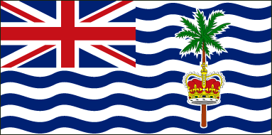
The national flag of British Indian Ocean Territory was adopted on November 8, 1990. The flag depicts six white and six colored curvy horizontal bands. The British Union Flag is depicted in the upper segment of the hoist-side quadrant.
The remaining half part of the British Indian Ocean Territory Flag consists of a stripy fragment that holds a palm tree and yellow crown. The ratio of the flag is 1:2. The green palm tree and the crown are pictograms of the Indian Ocean Territory.
| Official Name: | British Indian Ocean Territory |
| Proportion: | 1:2 |
| Adopted on: | November 8, 1990 |
| Location: | Situated in the Indian Ocean, halfway between Africa and Indonesia |
| Capital City: | Diego Garcia |
| Area: | 21,004 square miles |
| Population: | 4000 |
| Currency: | United States dollar (USD) |
| Official Language: | English |
| National Anthem: | God Save the Queen |
