- Turkey Syria Earthquake 2023 - Syria Map, Turkey Map, Syria Turkey Map, Syria Lat Long, Turkey Lat Long, Syria Political Map, Idlib Map, Gaziantep Map, Turkey 2011 Earthquake, Fault Line Map
- Syria Provinces - Al Hasakah, Ar Raqqah, As Suwayda, Aleppo, Damascus , Daraa, Deir ez-Zor, Hama, Homs, Idlib, Latakia, Quneitra, Rif Dimashq, Tartus
- Neighboring Countries - Lebanon, Iraq, Jordan, Israel
- Continent And Regions - Asia Map
- Other Syria Maps - Syria Map, Where is Syria, Syria Blank Map, Syria Road Map, Syria Rail Map, Syria River Map, Syria Cities Map, Syria Physical Map, Syria Flag
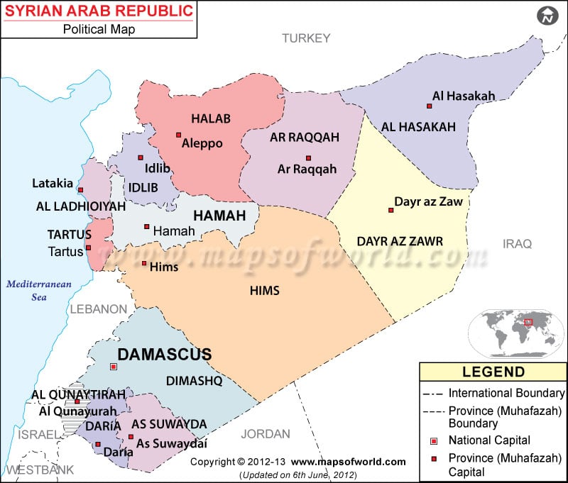
Syria lies on the coordinates of 35° North latitude and 38° longitude. Its neighboring countries are Turkey, Jordan, Israel and Lebanon. The capital of Syria is Damascus and is situated 691 meters above sea level. The Muhafazah capitals are marked with white squares on the Syria map.
The printable map of Syria is very useful for students and travelers.
Syria political map is a visual representation of the country’s location, Muhafazah boundaries and their capitals. The map also features the country capital, Damascus marked with a red dot. The geographical coordinates of the country are 35° North latitude and 38° longitude. The Syria map also features the neighboring countries of Syria and the Mediterranean Sea.
Location of Syria
The political map of Syria places the country in Middle East sharing its border with Turkey in the north, Jordan in the south, Israel and Lebanon in the west. The latitudinal and longitudinal extent of the country is 35° North and 38° East respectively. Syria occupies a total area of 185,180 square kilometers, of which the land area covered is 184,050 square kilometers. The remaining 1,130 square kilometers is covered by waterbodies. The coastline of Syria stretches over 193 kilometers and is outlined by a blue line on the online map of Syria. The highest point of Syria is Mount Hermon, situated 2,814 meters above sea level. The lowest point is near Lake Tiberias, which is 200 meters below sea level.
Capital of Syria
The red dot on the printable map of Syria points to the capital of Syria, Damascus. The city stands 691 meters above sea level. The latitudinal and longitudinal extent of the city is 33° 30′ North and 36° 17′ 60” East. Geographically, the capital city stands on the southwestern part of Syria. The city is famous as the oldest city incessantly inhabited by people of successive generations. The nearby cities are Al Muhajirin, Ad Dahdah, As Salihiyah, Al Qanawat, Maydan, Ayn Tarma, Jawbar, Amara al Juwaniyah and Mukhayyam al Yarmuk. Mezze, Dumayr, Damascus International and the Marj Ruhayyil are the main airports of the city.
