- Sweden Cities - Gothenburg, Malmö, Stockholm, Uppsala
- Neighboring Countries - Norway, Finland, Denmark, Estonia, Poland
- Continent And Regions - Europe Map
- Other Sweden Maps - Sweden Map, Where is Sweden, Sweden Blank Map, Sweden Road Map, Sweden Rail Map, Sweden River Map, Sweden Physical Map, Sweden Flag
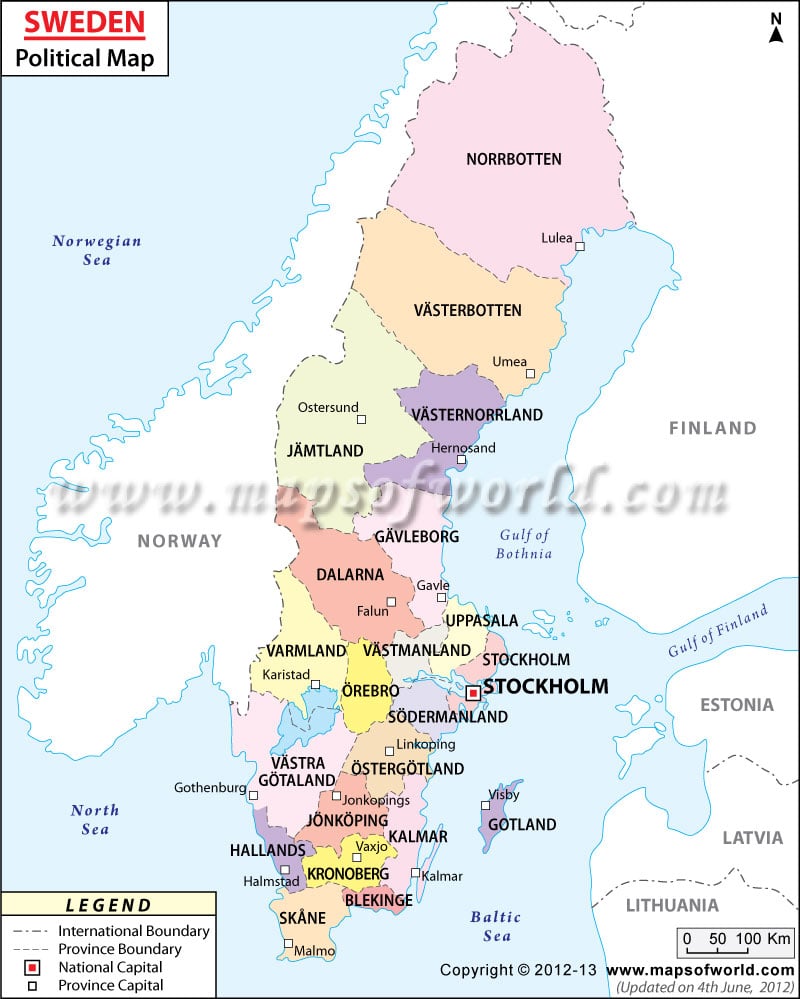
Sweden political map shows the provinces along with their capitals and the national capital. The broken lines on the Sweden map mark the provincial boundaries.
The red dot and the white squares featuring on the political Sweden map denote the national capital and province capitals of the country. Sweden is a piece of land jutting out in the Baltic Sea and borders with Finland and Norway. Stockholm is the capital of the country.
Sweden political map displays the different administrative divisions, which constitute to form the Kingdom of Sweden. The country borders with countries like Finland and Norway and also with Baltic Sea and Gulf of Bothnia. Stockholm is the capital of the country situated near the coast. The geographical coordinates of the country are 62° North latitude and 15° East longitude.
Geography of Sweden
The political map of Sweden points the country as a piece of land jutting out into the Baltic Sea. The latitudinal and longitudinal extent of Sweden are 62° North and 15° East respectively. The total area of the country is 449,964 square kilometers. The land area of the country is 410,934 square kilometers and the remaining 39,030 square kilometers is covered by water bodies. Around 3,218 kilometers make up the coastline of Sweden. The highest point of the country is Kebnekaise, standing at a height of 2,111 meters above sea level. The lowest point is considered as the reclaimed Bay of lake Hammarsjon.
| County | Population | Area(km.²) | Area(mi.²) | Capital | Swedish |
|---|---|---|---|---|---|
| Blekinge | 151,436 | 3,055 | 1,180 | Karlskrona | Blekinge lan |
| Dalarna | 275,711 | 30,404 | 11,739 | Falun | Dalarnes lan |
| Gavleborg | 275,653 | 19,756 | 7,628 | Gavle | Gavleborgs lan |
| Gotland | 57,297 | 3,184 | 1,229 | Visby | Gotlands lan |
| Halland | 288,859 | 5,720 | 2,208 | Halmstad | Hallands lan |
| Jamtland | 127,020 | 54,100 | 20,888 | Ostersund | Jamtlands lan |
| Jonkoping | 331,539 | 11,253 | 4,345 | Jonkoping | Jonkopings lan |
| Kalmar | 233,776 | 11,694 | 4,515 | Kalmar | Kalmar lan |
| Kronoberg | 179,635 | 9,429 | 3,641 | Vaxjo | Kronobergs lan |
| Norrbotten | 251,886 | 106,012 | 40,931 | Lulea | Norrbottens lan |
| Orebro | 275,030 | 9,343 | 3,607 | Orebro | Orebro lan |
| Ostergotland | 417,966 | 11,646 | 4,497 | Linkoping | Ostergotlands lan |
| Skane | 1,184,500 | 11,369 | 4,389 | Malmo | Skane lan |
| Sodermanland | 263,099 | 6,607 | 2,551 | Nykoping | Sodermanlands lan |
| Stockholm | 1,918,104 | 6,789 | 2,621 | Stockholm | Stockholms lan |
| Uppsala | 319,925 | 7,206 | 2,782 | Uppsala | Uppsala lan |
| Varmland | 273,489 | 19,388 | 7,486 | Karlstad | Varmlands lan |
| Vasterbotten | 257,581 | 59,284 | 22,890 | Umea | Vasterbottens lan |
| Vasternorrland | 243,978 | 23,107 | 8,922 | Harnosand | Vasternorrlands lan |
| Vastmanland | 248,489 | 6,614 | 2,554 | Vasteras | Vastmanlands lan |
| Vastra Gotaland | 1,538,284 | 25,389 | 9,803 | Goteborg | Vastra Gotalands lan |
| 21 counties | 9,113,257 | 441,370 | 170,414 |
 Wall Maps
 Sweden Facts