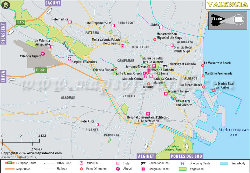
Valencia is the third largest city in Spain. The city founded by the Romans in 137 BC, derived its name from the word Valentia which means “Strength”. During the 15th and 16th centuries, it was one of the major cities in the Mediterranean. French under Marshal Suchet besieged it in 1811 during the Peninsular War. But later during the Spanish Civil War, the capital of the Republic was moved to Valencia. It is a medium-sized port city in the nation.
Tourist Attractions:
The various parks and gardens are wonderful recreational centers that draw in tourists from far and wide.
Transportation:
Valencia’s metro is a great relief to the commuters there. Trains, buses, and taxis are the other forms of public transportation in the city. As it is a port city, a ship or boat can be used for traveling. Valencia Airport serves the city.
Hotels:
The amazing locations of the Valencia hotels give a complete view of the city through its windows. The outstanding hospitality and lip-smacking dishes served to make these hotels unique. Hotel Europa, Hotel Vincci Lys, Hostal Moratin, Melia Plaza, Hospes Palau de la Mar, Hotel Neptuno, Ad Hoc Monumental Hotel, Silken Puerta Valencia and Eurostars Gran Valencia are some of the famous hotels in Valencia.
Places of Attraction:
Elements of Baroque and Romanesque architecture, Mercado Central, a science museum, IMAX cinema oceanographic park, and The Music Palace -the example of modern architecture in Valencia are the wonderful architectures of the city. Plaza del Ayuntamiento- the largest square, Turia gardens that contain a children’s playground, a fountain, and sports fields is the main symbol of the city. Palm Groves (Palmeral) of Elche, Valencia Botanical Gardens, Fallas Museum, and Miguelete are the other interesting spots in the city that gains the attention of the tourists. The Real, Monforte, and Botanic gardens are the other gardens in the city.
| COUNTRY | Spain |
| GEOGRAPHIC COORDINATES | Latitude 39º29′ N, Longitude 0º22′ W |
| AREA | 134.65 sq. km |
| POPULATION | 836900 estimated |
