- Neighboring Countries - Papua New Guinea
- Continent And Regions - Oceania Map
- Other Solomon Islands Maps - Solomon Islands Map, Where is Solomon Islands, Solomon Islands Blank Map, Solomon Islands Cities Map
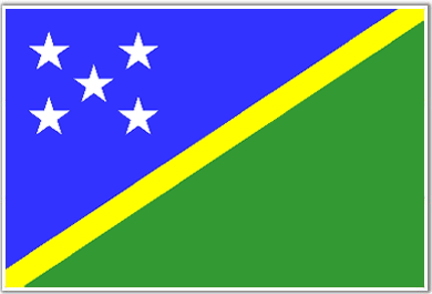
The flag with proportion of 1:2 integrates slender diagonal yellow band of color that divides the flag into two segments. The upper portion of the ensign is blue and the underside segment is green.
In the blue fragment five white colored, stars with five points are ordered in a form of X.The blue color denotes the water of Pacific Ocean; whereas the yellow strip represents the sunlight and the green segment symbolizes the fruitfulness of the state.Initially, the five stars used to suggest the five governmental territories of Solomon Island.
| Official Name: | Soloman Islands |
| Capital: | Honiara |
| Location: | In Melanesia east of new Guinea (Guadalcanal Santa Isabel, Malaita New Gerogia San Cristobal Santa Cruz and other Islands) |
| Area: | 28, 450 Sq. km. |
| Official Languages: | English |
| National Flag: | Divided blue over green by a diagonal yellow band and in the canton 5 white stars. |
| National Anthem: | God Save Our Solomon Islands (1978) |
| National symbol(s): | |
| National colors: | blue, yellow, green, white |
| National anthem: | |
| Name: | “God Save Our Solomon Islands” |
| Lyrics/Music: | Panapasa BALEKANA and Matila BALEKANA/Panapasa BALEKANA |
Fact about Solomon Islands flag |
| Country | Solomon Islands |
|---|---|
| Designed by | NA |
| Adopted | 18. November 1977 |
| Revision | NA |
| Design and Colors | A blue and green flag divided by a yellow diagonal radiating from the lower-hoist side corner; with five white, five-pointed stars (2-1-2) in the canton. |
| Size Ratio | 1:2 |

 Solomon Islands Facts