- Neighboring Countries - Czech Republic, Austria, Hungary, Poland, Ukraine
- Continent And Regions - Europe Map
- Other Slovakia Maps - Slovakia Map, Where is Slovakia, Slovakia Blank Map, Slovakia Road Map, Slovakia Rail Map, Slovakia River Map, Slovakia Cities Map, Slovakia Physical Map, Slovakia Flag
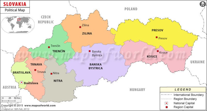
Slovakia, a central European country, had the population of 5,447, 502 as per the estimate of July 2007. The residents of the country are known as Slovaks. Slovakia was separated from Czechoslovakia on 1st January 1993. The country is officially known as Slovak Republic. In Slovakia political map, the boundaries, national capital, administrative divisions and major cities of the country have been indicated.
Slovakia Features
Slovakia is a country of Central Europe. The landscape of the country is mainly mountainous. The geographic coordinates of the country are 48° 40′ North latitude and 19° 30′ East longitude. The country experiences temperate climate. Multi party system prevails at Slovakia and the country is a parliamentary democratic republic.
Slovakia Capital
The capital of Slovakia is Bratislava. Some of the neighboring cities of Bratislava are Koliba, Vinohrady, Petrzalka, Nivy, Nove Mesto, and Ovsiste. The national capital is located in the southwestern part of the country. Bratislava is home to many of the major financial and business institutions of the country. The geographic coordinates of Bratislava are 48° 8′ 60″ North latitude and 17°7′ East longitude. The capital city is 433 feet above sea level. The airport that is located at Bratislava is Ivanka airport.
Slovakia Boundaries
The international boundaries of the country are indicated by black lines of a particular pattern. Hungary, Ukraine, Austria, Poland and Czech Republic are the neighboring countries of Slovakia. The north direction is pointed out in the political Slovakia map.
Slovakia Administrative Divisions
The country has been divided into eight regions for administrative purpose. The regions of the country are Bratislavsky kraj, Banskobystricky kraj, Nitriansky kraj, Kosicky kraj, Trenciansky kraj, Presovsky kraj, Zilinsky kraj and Trnavsky kraj.
Slovakia Cities
The cities of Slovakia have been marked in the political printable Map of Slovakia by black dots. Some of the important Slovakia cities are:
|
|
| Region | Population | Area(km.²) | Area(mi.²) | Slovak Name | German | Former |
|---|---|---|---|---|---|---|
| Banska Bystrica | 662,121 | 9,455 | 3,651 | Banskobystricky | Neusohl | Central, East |
| Bratislava | 599,015 | 2,052 | 792 | Bratislavsky | Prebburg | Bratislava, West |
| Kosice | 766,012 | 6,752 | 2,607 | Kosicky | Kaschau | East |
| Nitra | 713,422 | 6,344 | 2,449 | Nitriansky | Neutra | West |
| Presov | 789,968 | 8,981 | 3,468 | Presovsky | Preschau | East |
| Trencin | 605,582 | 4,502 | 1,738 | Trenciansky | Trentschin | West, Central |
| Trnava | 551,003 | 4,147 | 1,601 | Trnavsky | Tyrnau | West |
| Zilina | 692,332 | 6,801 | 2,626 | Zilinsky | Sillein | Central |
| 8 regions | 5,379,455 | 49,034 | 18,933 |
