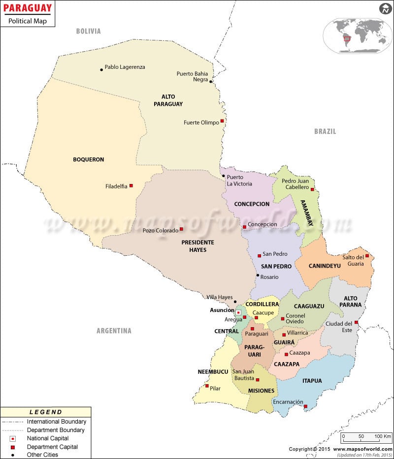
- Paraguay Departments - Alto, Alto Parana, Amambay, Asunción, Boqueron, Caaguazu, Caazapa, Canindeyú, Central, Concepcion, Cordillera, Guaira, Itapua, Misiones, Neembucu, Paraguari, Presidente Hayes, San Pedro
- Paraguay Cities - Asuncion
- Neighboring Countries - Argentina, Uruguay, Bolivia, Brazil
- Continent And Regions - South America, Americas
- Other Paraguay Maps - Paraguay Map, Where is Paraguay, Paraguay Blank Map, Paraguay Road Map, Paraguay Railway Map, Paraguay Physical Map, Paraguay Flag
Paraguay Political Map provides the locations and the names of the important places and departments of Paraguay along with the major cities of the country. This Central South American country is situated in the north-east of Argentina.
It is bordered by the countries of Bolivia and Brazil.
Paraguay Geography :
Paraguay Political Map depicts that it is a Central South American country located in the north-east of Argentina. This country is bordered by Bolivia in the north and Brazil in the east. Paraguay lies on the latitude and longitude of 23° South and 58° West respectively. This landlocked country covers an area of about 406,750 sq km.
Capital City :
Asuncion, which is the national capital of Paraguay, is shown on the Paraguay Political Map by a red square box. It is located on the geographical coordinates of 25° 16° South and 57° 40° West latitude and longitude respectively. It is situated at an altitude of 54 meters above sea level. Formosa and Silvio Pettirossi International are the nearest airports.
Departments of Paraguay :
The various departments into which Paraguay is divided are shown on the Printable Map of Paraguay by jet black bold fonts. These departments are:
- Alto Paraguay
- Bouqueron
- Concepcion
- Amambay
- Presidente Hayes
- San Pedro
- Canindeyu
- Neembucu
- Cordillera
- Alto Parana
- Caaguazu
- Central
- Paraguari
- Guaira
- Caazapa
- Itapua
- Misiones
| Department | Population | Area(km.²) | Area(mi.²) | Capital |
|---|---|---|---|---|
| Alto Paraguay | 11,587 | 82,349 | 31,795 | Fuerte Olimpo |
| Alto Parana | 558,672 | 14,895 | 5,751 | Ciudad del Este |
| Amambay | 114,917 | 12,933 | 4,993 | Pedro Juan Caballero |
| Asuncion | 512,112 | 117 | 45 | Asuncion |
| Boqueron | 41,106 | 91,669 | 35,394 | Filadelfia |
| Caaguazu | 435,357 | 11,474 | 4,430 | Coronel Oviedo |
| Caazapa | 139,517 | 9,496 | 3,666 | Caazapa |
| Canindeyu | 140,137 | 14,667 | 5,663 | Salto del Guaira |
| Central | 1,362,893 | 2,465 | 952 | Aregua |
| Concepcion | 179,450 | 18,051 | 6,970 | Concepcion |
| Cordillera | 233,854 | 4,948 | 1,910 | Caacupe |
| Guaira | 178,650 | 3,846 | 1,485 | Villarrica |
| Itapua | 453,692 | 16,525 | 6,380 | Encarnacion |
| Misiones | 101,783 | 9,556 | 3,690 | San Juan Bautista (de las Misiones) |
| Neembucu | 76,348 | 12,147 | 4,690 | Pilar |
| Paraguari | 221,932 | 8,705 | 3,361 | Paraguari |
| Presidente Hayes | 82,493 | 72,907 | 28,150 | Villa Hayes |
| San Pedro | 318,698 | 20,002 | 7,723 | San Pedro (del Ycuamandiyu) |
| 18 divisions | 5,163,198 | 406,752 | 157,048 |
