- Neighboring Countries - South Africa, Botswana, Zimbabwe, Zambia, Angola
- Continent And Regions - Africa Map
- Other Namibia Maps - Namibia Map, Where is Namibia, Namibia Blank Map, Namibia Road Map, Namibia Rail Map, Namibia River Map, Namibia Cities Map, Namibia Political Map, Namibia Flag
Namibia is known as the Republic of Namibia, officially is a country in Southern Africa. It shares its boundary with the Atlantic Ocean to the west, South Africa to the south and east, Zambia and Angola to the north, Botswana to the east. The Zambezi river separates Namibia from Zimbabwe. Namibia covers a total area of 825,615 km2 (318,772 sq mi).
Namibia Physical Features
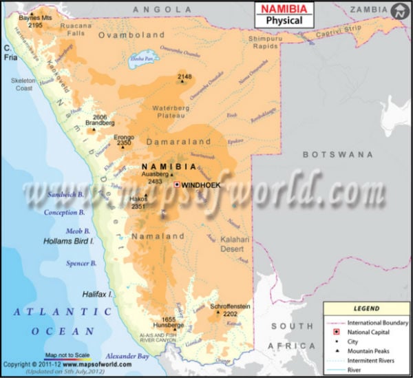
This Namibia Physical Map shows geography and trends in the height of Namibia. Latitudes and Longitudes of Namibia can also be noted. The latitudinal extent of the country is between 17. S and 29.S and the longitudinal dimension of the country are between 11. E and 26. E. The capital of Namibia, Windhoek, is also marked on the map. The landscape of Namibia consists of five topographical areas, which are:
Central Plateau
The Central Plateau region runs from north to south. It shares its boundary with Orange River to the south, the Namib Desert and its coastal plains to the southwest, the Skeleton Coast to the northwest, the Kalahari Desert to the east. The elevation of the central plateau ranges from 3,200-6,500 feet (975-1980 metres). The highest point of Namibia is Konigstein, at a height of 2,606 meters (8,550 ft). The plateau regions are the core of the agricultural life of Namibia.
Coastal Desert
The area includes the Namib Desert and Namib-Naukluft National Park. The coastal desert in Southern Africa is one of the oldest deserts in the world. The Namib Desert consists of the extensive Namib Sand Sea along the central coast and the Skeleton Coast and Kaokoveld in the north. The desert region is the richest source of diamonds on earth and is 50 to 80 miles wide over most of its length.
Kalahari Desert
The Kalahari Desert is a gently undulating, featureless, sand-covered plain known as Namibia’s best geographical feature. The succulent Karoo is an ecoregion in the Kalahari Desert in Namibia, a biodiversity hotspot home to above 5,000 species of plants. Another feature of the Kalahari Desert in Namibia is inselbergs.
Great Escarpment
This region consists of steep slopes from the high central Southern African Plateau in the oceans surrounding Southern Africa on three sides. The Great Escarpment has a height of over 2,000 meters (6,562 ft). The area is rocky with poorly developed soil, and Acacia species are found.
Bushveld
In northeastern Namibia, the region is found in the Caprivi Strip along the Angolan border. The area was a narrow corridor demarcated for the German Empire to access the Zambezi River. The region receives a more significant amount of precipitation than the rest of the country. The Etosha pan is a large endorheic Salt Pan adjacent to the Bushveld in north-central Namibia.
Drainage System of Namibia
The rivers on the border of Namibia are the only permanent rivers of the country. Most of the rivers in the country rise on the plateau and die out downstream in the Kalahari or Namib desert. The kuiseb river and Swakop rivers rise on the plateau and die out in the Namib. The fish river also grows on the central plateau and flows south to the orange.
