- Mauritius Cities - Port Louis
- Continent And Regions - Africa Map
- Other Mauritius Maps - Mauritius, Where is Mauritius, Mauritius Blank Map, Mauritius Road Map, Mauritius Rail Map, Mauritius Flag
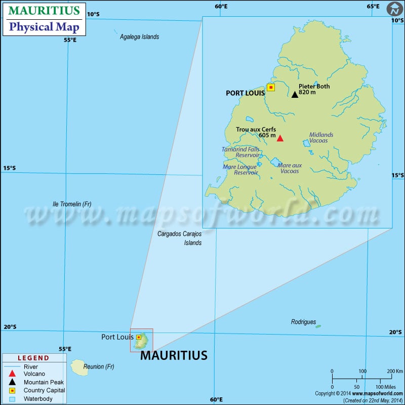
Latitudes and Longitudes of Mauritius can also be noted. Mauritius, known as the Republic of Mauritius, officially is an island nation in the Indian Ocean. The country is about 2,000 kilometres (1,200 mi) off southeast of the African continent. The country consists of the main island Mauritius and several other islands.
The other islands are Rodrigues, St. Brandon and Sgalega physiographically; they all are part of the Mascarene Islands. Port Louis is the capital and largest city on Mauritius’s main island and is marked on the map. The latitudinal extent of the island nation is between 19.58.8’S and 20.31.7’S, and the longitudinal dimension of the island nation is between 57.18.0’E and 57.46.5’E. A map legend featured at the bottom helps all the signs, characters, graphics, and symbols used throughout the map.
Mauritius Physical Features
The Mauritius exclusive economic zone covers about 2.3 million km2 (890,000 sq mi) of the Indian Ocean. The total area of the country is 2,040 km2 (790 sq mi), with its land area about 1,864.8 km2 (720.0 sq mi). The main island Mauritius is volcanic in origin. The country’s terrain consists of a small coastal plain rising to small discontinuous mountains encircling a central plateau. The island nation is surrounded by more than 150km of white sandy beaches, protected by the island’s coral reefs. The relief features of the country are:
Mountain Range
The mountain ranges on the island form a ring indicating that they all belong to one giant volcano one time. Moka range in Port Louis is the longest one. Other mountain ranges with distinct features are Pieter Both Mountain having a rock perched on the top, Le Pouce Mountain having a shape like a thumb, Trois Mammelles having three peaks and Montagne Blanche, which is named after the grey-white colours of the rocks found on the mountain. A few isolated peaks are also like Tourelle du Tamarin and Corps De Garde.
Central Plateau
The central plateau lies inside the ring of mountain ranges in the nation. The lava flow forms the table from several volcanoes. The central plateau is comparatively higher in the southwest. The plateau slopes gradually towards the north and turns into an undulating landscape eastwards.
Plains and Trou aux Cerfs volcano
The coastal plains of the island nation are located outside the ring of mountain ranges. The plains in the north are, known as northern plains, are the longest ones. These plains were formed from lava flowing from the volcanoes. Some of them are Butte aux Papayas, Mount Pilton, Flacq plains, Grand Port and more.
Trou aux Cerfs volcano is one of the most significant volcanic structures on the island. It is a circular depression reaching 350 meters at the surface. Situated in the town of Curepipe, it is one of the major tourist attractions in the nation because of its accessibility and panoramic view.
Important Rivers in Mauritius
The two important rivers of the island nation are the Black River and Grand River South East. They are the primary sources of hydroelectric power in the country. Other than that, Lake Cacao is the main reservoir and significant water source.

 Mauritius Islands