| Facts About Bamako | |
|---|---|
| Country | Mali |
| State | Bamako |
| Founded | 14th century |
| Area | 245.0 km2 |
| Population | 1809106 |
| Lat Long Coordinates | 12°39′N8°0′W |
| Time Zone | UTC+0 |
| area Code | 223 |
| Language | French and Bambara |
| Major Religion | Christian |
| Point of interest | Bozo Village, Bamako Grand Mosque, National Museum of Mali |
About City :
The sixth fastest growing city in the world, Bamako, the capital of Mali is located on the Niger River. It is the largest city in Mali and is the administrative center as well as a major regional trade and conference center of the country. It has an estimated population of over 1.8 million. Traveling around this city might prove to be difficult because of its mostly unpaved and overcrowded roads, crammed with motor vehicles.
Bamako’s traditional heritage dates back to the Paleolithic age. During the Middle Ages, the city grew because of its cotton and salt trade. It became the capital of French Sudan in 1908 and remained the capital when Mali gained independence in 1960.
Geography :
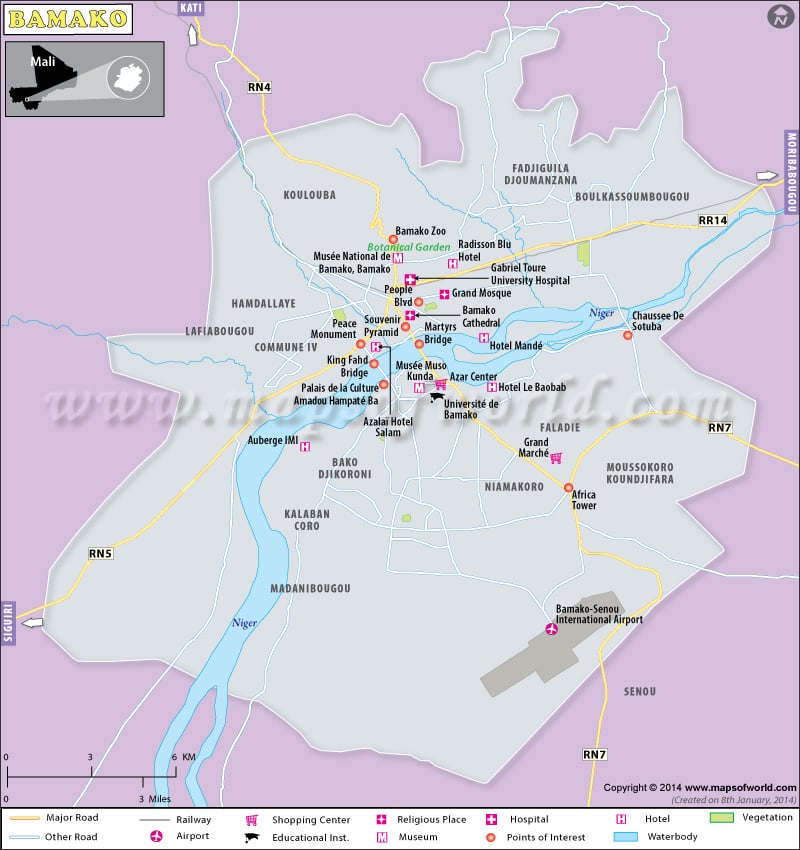
Situated on the banks of the river Niger, Bamako is essentially flat where topography is concerned except for the remains of an extinct volcano to its immediate north. Although it initially developed on the northern side of the river, bridges have been now developed which connect the northern and the southern banks and the city has spread to both sides of the river.
How to Reach (Transport) :
The city is about 15 km from the Bamako-Sénou airport with flights from Europe offered by Air France from Paris and by Royal Air Maroc via Casablanca. Undergoing constant renovations since 2009, the airport remains incomplete, cramped and difficult to navigate. Bamako is also accessible by train across western Africa and by bus from Sogoniko. Much of the navigation is done by the Niger River and the city, sprawled on both sides of the river is well connected by two bridges, viz., The Bridge of Martyrs and The King Fahd Bridge.
Inside the city, taxi-motorcycles or Taxi vans (Sotramas) are the easiest and most effective way of traveling. Although neither run on meter, the prices are relatively cheap.
When to Visit :
With a tropical dry and wet climate, Bamako is hot and humid all year around. The best time to visit would be November to about March when the climate is dry. During these months, there is a lesser chance of encountering an otherwise muddy and mosquito riddled environment.
Fairs and Festivals :
Incredibly rich in culture, Bamako borrows from the several kingdoms that ruled it until its independence. To start with, the city celebrates their Independence Day on 22nd September, when they got their freedom from France.
The month of November encompasses the three most important festivals of the city –
- The Hot air balloon festival makes the entire November full of regular hot air balloon flights and tours.
- The Bamako Festival of African photography, now an international event, is a bi annual display of African art in the city and the influence of the French on them.
- The Bamako Dance Festival, where numerous dancers strive to show off their talent, highlighting traditional and contemporary dances of many African nations as well as Europe.
At the end of January, the city also serves as the finish line to the grueling trans-Sahara rally in which, on the last Sunday of January, hundreds of rally vehicles, both two wheelers and four wheelers , reach the city.
Points of Interest (Places to Visit) :
Among the many points of interest, the following are the most noteworthy –
- The Grand Marché or the Great Market and the Maison des Artisans which beautifully show off the colourful cultural diversity among the many ethnic groups of Mali.
- The National Museum which is an anthropological and archaeological museum began under the French rule and has nearly 3000 finds. The labels on the exhibits are not in English but English guides are readily available.
- The Bamako Grand Mosque, built on the site of a pre-colonial mud-brick mosque, is one of the tallest buildings in Bamako and is often open to tourists.
- Point G. Hill which offers a very good view of the city and has caves with rock paintings.
- The BCEAO Tower, the tallest building in West Africa, is modeled on the Sudano-Sahelian architecture and is located on the left bank of river Niger.
- The National Library of Mali, created in 1944 by the French holds more than 60,000 works easily accessible to the public. However, a nominal fee has to be paid for borrowing privileges. Some of the exhibits of the biannual Bamako photography festival are hosted here.
Other noteworthy places would be the Bamako Cathedral, the Muso Kunda Museum, the Independence Monument, Bamako Zoo, Monument de la Paix, and the Botanical gardens.
Accommodation :
There is quite a variety of places to put up at. Posh choices would be Laico Hotel de l’Amitié, Alazai Hotel Salam, Hotel Sahel Vert, Radisson Blu, Hotel Le Rabelais, etc which offer nice and clean rooms, free wi-fi, good restaurants, swimming pools, etc. For the humble, the Bed & Breakfast Ambassagou, Mission Libonaise, amongst others offer good services.

 Mali Attractions