- Neighboring Countries - Uzbekistan, Kyrgyzstan, Turkmenistan, China, Russia
- Continent And Regions - Asia Map
- Other Kazakhstan Maps - Kazakhstan Map, Where is Kazakhstan, Kazakhstan Blank Map, Kazakhstan Road Map, Kazakhstan Rail Map, Kazakhstan River Map, Kazakhstan Cities Map, Kazakhstan Physical Map, Kazakhstan Flag
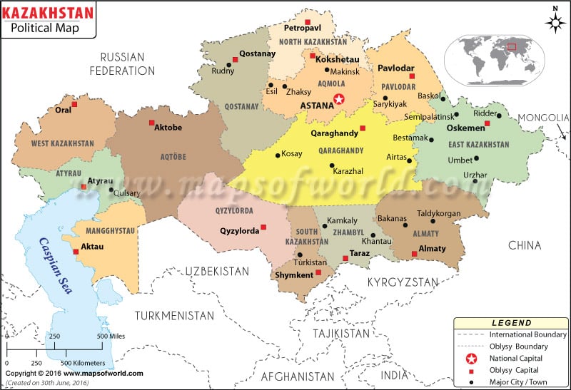
In the political map of Kazakhstan, the international boundaries, important cities and the national capital have been marked by using specific symbols. The terrain of the country is diverse. The country has abundant supply of fossil fuel and mineral resources.
The country maintains stable relationship with all the neighboring countries.
Kazakhstan Features
Kazakhstan is a country located in Central Asia. A small part of the country lies in the eastern region of Europe. The geographical coordinates of Kazakhstan are 48° North latitude and 68° East longitude. The total area that the country covers is 2,717,300 square kilometers. In the political map of Kazakhstan, the boundaries of oblys, capitals of the oblys, international boundaries, neighboring countries are highlighted in a clear manner.
Kazakhstan oblys Capitals
There are 14 provinces or oblys in the country Kazakhstan. The capitals of the oblys have been marked in the political map of Kazakhstan by green boxes. The marked capitals of Kazakhstan oblys are:
|
|
|
|
|
|
|
|
|
|
|
|
|
Kazakhstan Capital
Astana is the capital of Kazakhstan. Astana ranks second in terms of size in Kazakhstan. The meaning of Astana is “capital city”. The city is positioned at the middle of the country. The city also happens to be the second coldest city of the world. The geographical coordinates of Astana are 51° 10′ 52″North latitude and 71° 25′ 40″ East longitude. Astana lies 1112 feet above sea level. The capital city of Kazakhstan has been highlighted in the political map by a red star. The city is served by Astana International Airport. Some of the cities located in close proximity to Astana are:
|
|
|
|
|
Kazakhstan Boundaries
Aral Sea is located to the southern side and Caspian Sea is positioned at southwestern border of the country. The neighboring countries of Kazakhstan that have been pointed in the printable map of Kazakhstan are:
|
|
|
|
|
|
Kazakhstan Cities
In the country, Kazakhstan the major cities have been highlighted by using black dots. Some of the indicated cities of Kazakhstan in the political printable map of Kazakhstan are:
|
|
|
|
|
|
|
|
|
|
|
|
|
|
|
| Regions | Pop-2009 | Pop-1999 | Area(km.²) | Area(mi.²) | Capital |
|---|---|---|---|---|---|
| Almaty | 1,807,894 | 1,559,522 | 224,000 | 86,500 | Taldykorgan |
| Almaty [City] | 1,365,632 | 1,130,068 | 300 | 100 | Almaty |
| Aqmola | 737,495 | 835,661 | 146,200 | 56,400 | Kokshetau |
| Aqtobe | 757,768 | 682,793 | 300,600 | 116,100 | Aqtobe |
| Astana | 613,006 | 319,318 | 700 | 300 | Astana |
| Atyrau | 510,377 | 439,900 | 118,600 | 45,800 | Atyrau |
| Bayqonyr (1) | Bayqonyr | ||||
| East Kazakhstan | 1,396,593 | 1,530,792 | 283,200 | 109,300 | oskemen |
| Mangghystau | 485,392 | 316,847 | 165,600 | 63,900 | Aqtau |
| North Kazakhstan | 596,535 | 725,932 | 98,000 | 37,800 | Petropavlovsk |
| Pavlodar | 742,475 | 806,034 | 124,800 | 48,200 | Pavlodar |
| Qaraghandy | 1,341,700 | 1,411,401 | 428,000 | 165,300 | Qaraghandy |
| Qostanay | 885,570 | 1,019,560 | 196,000 | 75,700 | Qostanay |
| Qyzylorda | 678,794 | 596,344 | 226,000 | 87,300 | Qyzylorda |
| South Kazakhstan | 2,469,357 | 1,976,689 | 117,300 | 45,300 | Shymkent |
| West Kazakhstan | 598,880 | 617,624 | 151,300 | 58,400 | oral |
| Zhambyl | 1,022,129 | 983,935 | 144,300 | 55,700 | Taraz |
| 17 divisions | 16,009,597 | 14,952,420 | 2,724,900 | 1,052,100 |
