- Neighboring Countries - United Kingdom, France
- Continent And Regions - Europe Map
- Other Jersey Maps - Jersey Map, Where is Jersey, Jersey Blank Map, Jersey Flag
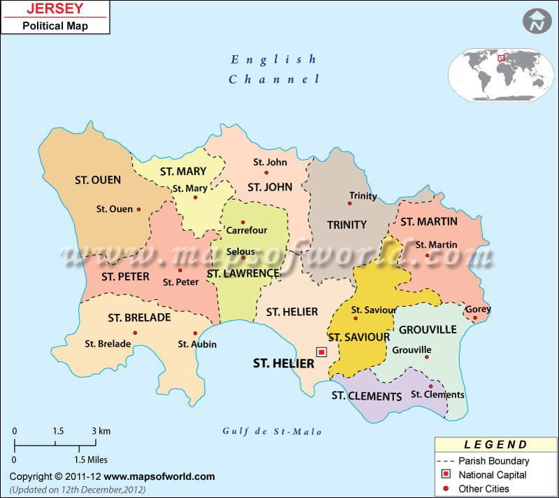
Located off the coast of Normandy, France, Jersey is the largest and southernmost of the Channel Islands. The island covers a total area of 45 square miles.
As shown in the map, Jersey is divided into twelve parishes for administrative purposes. The parishes are sub-divided into vingtaines. Each parish is administered by a Connetable, who is elected for a for a four-year term. All the parishes in Jersey border the sea. Saint Helier is the largest parish.
The other eleven parishes are:
- Saint Clement
- Saint Brelade
- Grouville
- Saint John
- Saint Lawrence
- Saint Martin
- Saint Mary
- Saint Ouen
- Saint Peter
- Saint Saviour
- Trinity
| Parish | Population | Area(km.²) | Area(mi.²) |
|---|---|---|---|
| Grouville | 4,866 | 8 | 3 |
| Saint Brelade | 10,568 | 13 | 5 |
| Saint Clement | 9,221 | 4 | 2 |
| Saint Helier | 33,522 | 11 | 4 |
| Saint John | 2,911 | 9 | 3 |
| Saint Lawrence | 5,418 | 10 | 4 |
| Saint Martin | 3,763 | 10 | 4 |
| Saint Mary | 1,752 | 7 | 3 |
| Saint Ouen | 4,097 | 15 | 6 |
| Saint Peter | 5,003 | 12 | 4 |
| Saint Saviour | 13,580 | 9 | 4 |
| Trinity | 3,156 | 12 | 5 |
| 12 parishes | 97,857 | 118 | 46 |

 Jersey Facts