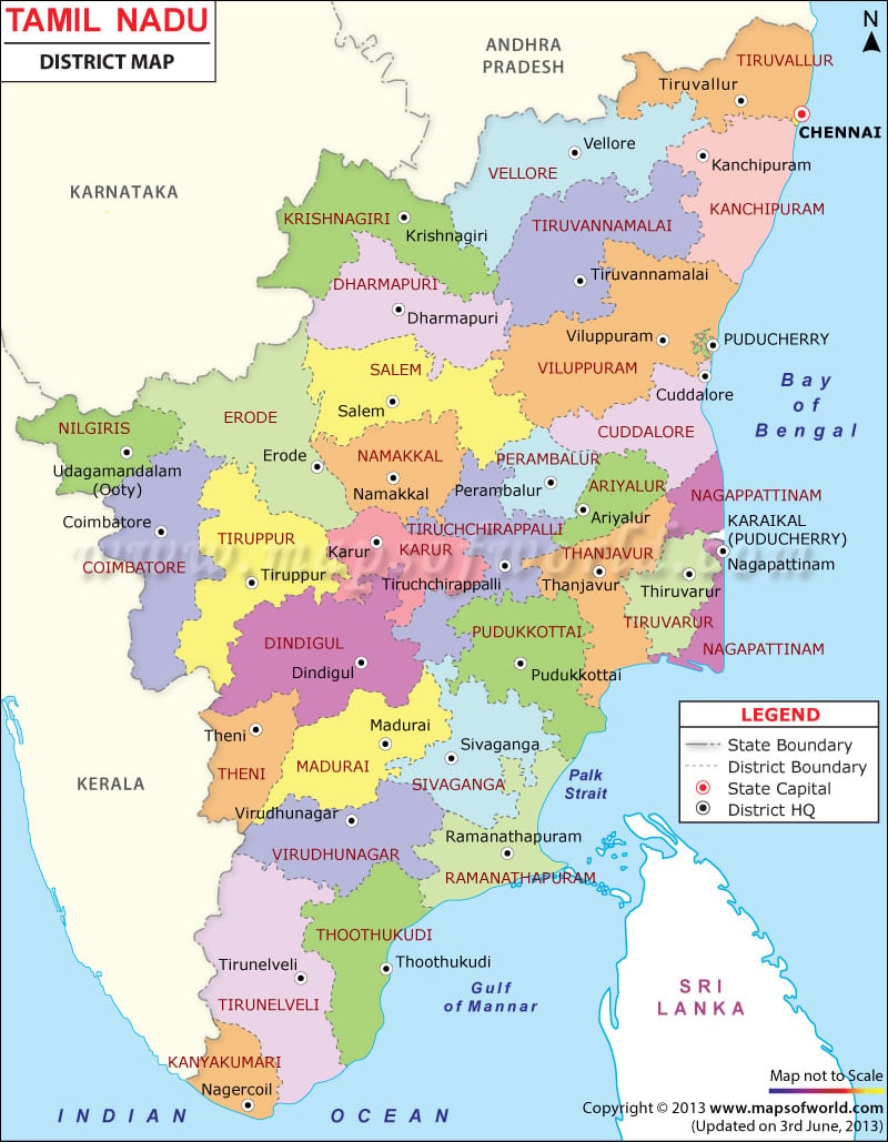
Tamilnadu Map

View detailed world maps that offer a global perspective—political, physical, and more.
Explore maps that visualize data on topics like population, climate, economy, and beyond.
Navigate the world with maps that guide your journeys—country and city maps for travelers.
Learn, discover, and share with educational maps, geography trivia, and cartographic insights—ideal for classrooms and curious minds.
FBrowse quick-reference lists for airports, area codes, capitals, postal codes, time zones, and more—organized for easy access.
Explore powerful mapping tools and services.
Order custom maps tailored to your most specific needs, whether for business, education, travel, or more!
Learn moreView detailed world maps that offer a global perspective—political, physical, and more.
Explore maps that visualize data on topics like population, climate, economy, and beyond.
Navigate the world with maps that guide your journeys—country and city maps for travelers.
Learn, discover, and share with educational maps, geography trivia, and cartographic insights—ideal for classrooms and curious minds.
FBrowse quick-reference lists for airports, area codes, capitals, postal codes, time zones, and more—organized for easy access.
Explore powerful mapping tools and services.

Facts About Tamil Nadu |
|---|
| Country | India |
| Capital | Chennai |
| Latitude and Longitude | 13.09°N 80.27°E |
| Number of Districts | 32 |
| Population | 72,138,958 (2011) |
| Area | 130,058 km2 (50,216 sq mi) |
| Languages | Tamil, Telugu, Malayalam |
| Time Zone | IST (UTC+05:30) |
| Postal Code | 6XXXXX |
| Area Code | +91 (India) – 4X(Chennai) / 4XX / 4XXX for other Cities |
| Airport Names | Chennai International Airport, Coimbatore Airport, Tiruchirapalli Airport, Madurai Airport |
| Ethnicity | Telugus |
| Points of Interest | Hogenakkal Falls, Dolphin’s Nose,Marina Beach, Arignar Anna Zoological Park, Vivekananda Rock Memorial, Shore Temple, Meenakshi Amman Temple, Airavatesvara Temple, Brihadeeswara Temple, Thirumalai Nayakkar Mahal, Fort Dansborg, Gulf of Mannar Biosphere Reserve, Nilgiri Biosphere Reserve, Agasthyamalai Biosphere Reserve, Sri Ranganathaswamy Temple, Basilica of Our Lady of Good Health, Erwadi Dargah, Mudumalai National Park |
| Demonym | Tamilian |
List of Tamil Nadu Districts |
|---|
| S.N. | District | Population (2011) | Area (sq km) |
|---|---|---|---|
| 1 | Ariyalur | 7,52,481 | 1949.31 |
| 2 | Chennai | 46,81,087 | 181 |
| 3 | Coimbatore | 34,72,578 | 572 |
| 4 | Cuddalore | 26,00,880 | 617 |
| 5 | Dharmapuri | 15,02,900 | 297 |
| 6 | Dindigul | 21,61,367 | 317 |
| 7 | Erode | 22,59,608 | 369 |
| 8 | Kanchipuram | 39,90,897 | 668 |
| 9 | Kanniyakumari | 18,63,174 | 995 |
| 10 | Karur | 10,76,588 | 323 |
| 11 | Krishnagiri | 18,83,731 | – |
| 12 | Madurai | 30,41,038 | 747 |
| 13 | Nagapattinam | 16,14,069 | 616 |
| 14 | Namakkal | 17,21,179 | 439 |
| 15 | Nilgiris | 7,35,071 | 422 |
| 16 | Perambalur | 5,64,511 | 1752 |
| 17 | Pudukkottai | 16,18,725 | 314 |
| 18 | Ramanathapuram | 13,37,560 | 284 |
| 19 | Salem | 34,80,008 | 575 |
| 20 | Sivaganga | 13,41,250 | 279 |
| 21 | Thanjavur | 24,02,781 | 638 |
| 22 | Theni | 12,43,684 | 381 |
| 23 | Thoothukudi | 17,38,376 | 340 |
| 24 | Thiruvarur | 12,68,094 | 492 |
| 25 | Tirunelveli | 30,72,880 | 400 |
| 26 | Tiruchirappalli | 27,13,858 | 536 |
| 27 | Thiruvallur | 37,25,697 | 776 |
| 28 | Tiruppur | 24,71,222 | – |
| 29 | Tiruvannamalai | 24,68,965 | 353 |
| 30 | Vellore | 39,28,106 | 573 |
| 31 | Villupuram | 34,63,284 | 412 |
| 32 | Virudhunagar | 19,43,309 | 409 |
Explore the map of Chennai, it is the capital city of the Indian state of Tamil Nadu. Situated on the southeastern coast region of the Bay of Bengal, it is the biggest commercial and industrial center in South India, and a major educational, cultural, and economic center.
Tamil Nadu Railway Map shows the district rail network, and railway stations and shows railway lines that flow in and outside of Tamil Nadu.
Tamil Nadu Road Map highlights the national highways and road network. The road map of Tamil Nadu shows the major roads, district HQ, etc.