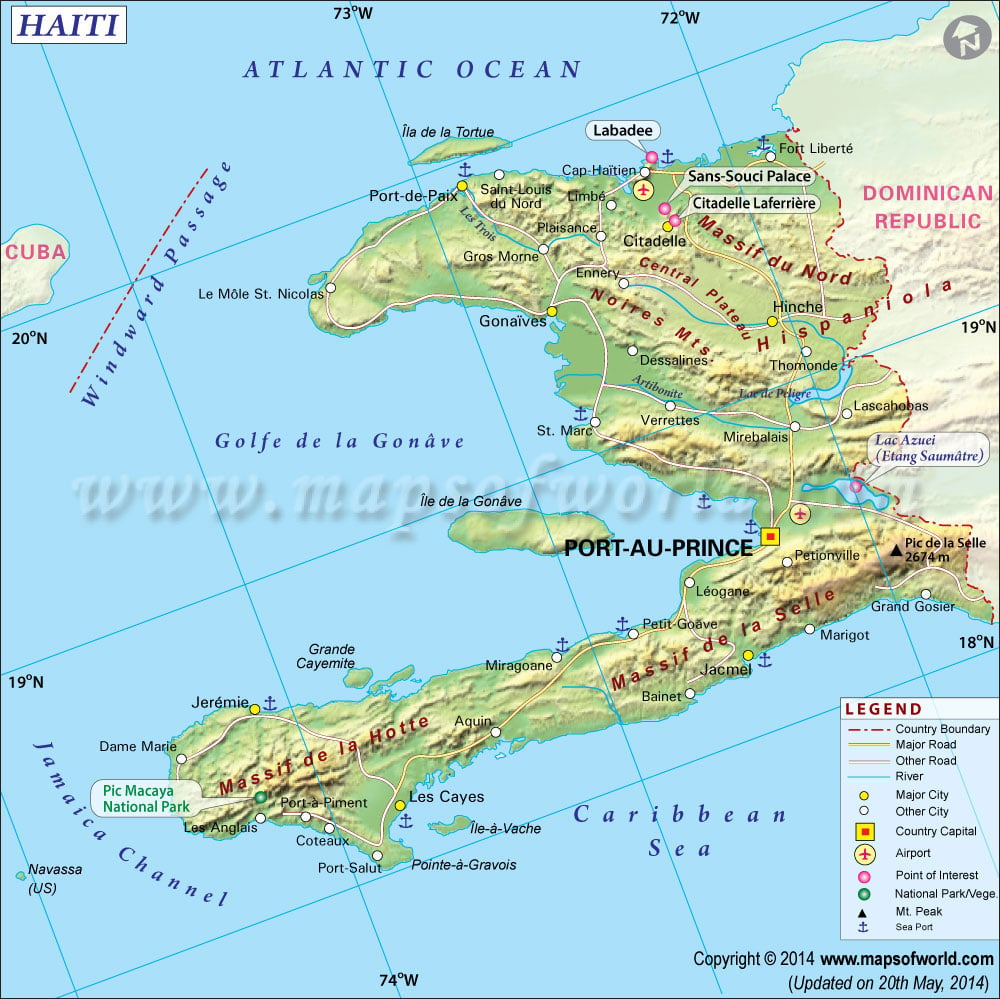
Haiti Map

- Neighboring Countries - Dominican Republic, Jamaica, Cuba
- Continent And Regions - North America Map, Americas Map
- Other Haiti Maps - Where is Haiti, Haiti Blank Map, Haiti Road Map, Haiti Rail Map, Haiti River Map, Haiti Cities Map, Haiti Political Map, Haiti Physical Map, Haiti Flag
Haiti is a Caribbean island nation located on the island of Hispaniola. The early inhabitants of the island were the Taino, an Arawak tribe who migrated from South America’s Amazon region to the Caribbean around 600.
The first Europeans to arrive on Hispaniola were the Spanish, with the voyage of Christopher Columbus, and the formation of settlements. The Spanish presence quickly led to the destruction of the native people. First, they were devastated by smallpox, and then those who remained were forced into labor. The French settled on Hispaniola, and the French West India Company controlled the colony. This initially caused conflict with Spain, until the 1697 Treaty of Ryswick, when the island was split into the Spanish eastern end, and the western third became the French colony of Santo Domingo. The French developed their colony and brought slaves from Africa to work in the sugarcane and tobacco plantations.
The slaves began to revolt at the end of the 18th century, fighting for their rights. France sent reinforcements to their colony to subdue the uprisings, but the colonial leaders ended slavery in Santo Domingo. When Napoleon’s troops arrived on the island in 1802, they were overpowered and defeated by 1803. Santo Domingo achieved independence as Haiti in 1804, but was only recognized as independent in 1825. The former colony was divided and in conflict, with the Kingdom of Haiti in the north and the Republic of Haiti in the south.
The island was unified under the direction of Jean Pierre Boyer, but the island was divided into Haiti and the Dominican Republic in 1844. Haiti worked to stabilize over the next decades, with overthrows, assassinations, and new governments. The US stepped in and occupied Haiti in 1915 as its protectorate, withdrawing by 1934. Since then, Haiti has experienced much instability, including dictators, a revolution, and a coup, but has by now stabilized.
Neighboring Countries :
Haiti shares a border with the Dominican Republic, and other nearby nations include Cuba, Jamaica, and Turks and Caicos.
Major Cities in Haiti
- Port-au-Prince (capital)
- Cap-Haitien
- Jacmel
Geography of Haiti
Haiti is located on the Caribbean island of Hispaniola, and is situated on the western end of the island, while the Dominican Republic occupies the rest of the island. Haiti’s name is derived from the Taino for “land of mountains,” and the mountains are the island’s main characteristic, with ranges covering the majority of the lands. The Massif du Nord is the main range in the north, while the Chaine de la Selle is in the south and the Massif de la Hotte in the west, where the highest point in Haiti is located at Pic la Selle, standing 2,680 meters (8,793 feet) above sea level.
Between the mountains are plains and valleys, like the Plain de l’Artibonite. Within the plains and valleys are some of Haiti’s lakes and rivers. Important rivers in Haiti are the Riviere l’Artibonite, which flows into the Gulf of Gonave, and the Guayamouc River. The lakes of Haiti include Lake Azuei and Trou Caiman, which are saltwater lakes, and Lake Peligre.
Haiti has many miles of coastline, with their beautiful beaches, and Haiti’s territory includes several other islands, including Ile de la Gonave, Tortuga, Ile a Vache, Les Cayemites, and Lanavaz.
Points of Interest :
Haiti has many scenic attractions, namely, its beaches and mountains. One of the country’s best beach resorts is located at Labadie, where most cruise ships make stops. The resort is walled in and the waters are clear and calm. Other major beaches are Paradis, a fairly private beach in a cove and Port-Salut in the south.
Haiti’s ports are frequently visited by cruise ships, where visitors can experience the Haitian culture from the markets and unique Creole foods to its traditional music and dances. The cities of Haiti display the country’s colonial past with French colonial architecture, combined with the colorful local flavors.
In the capital, Port-au-Prince, the Haitian culture and history can be seen in every corner. The city’s market, Marche de Fer, offers an eclectic mix of goods that includes tasty local snacks, handicrafts, and even some voodoo items. Additionally, the capital is home to museums, the National Palace, and the Haiti’s main cathedral. Cap-Hatien features fortresses, a citadel, including the UNESCO site, the Sans Souci Palace, which lies in ruins, and the renovated Citadelle Henri Christophe.
Much of Haiti was devastated in the 2010 earthquake and recovery is still in progress.
Transportation :
Haiti’s main international airports are Aeroport Toussaint L’Ouverture Airport in Port-au-Prince and Aeroport International Cap-Haitien. These airports are served by destinations across the Caribbean, as well as several locations in the Americas, and a few in Europe. There are also domestic flights between the two airports, as well as to the minor airports in smaller cities.
It’s also possible to enter Haiti by car or minibus from the Dominican Republic, which can be fairly quick and typically safe, but is only possible during the day. Mini buses are great for long-distance travel around Haiti. There are several car rental agencies that operate in Haiti and 4WD vehicles are recommended, as Haitian roads are not well maintained. The cheapest way to get around Haiti is via tap-taps, the preferred form of local transportation, which are vans or trucks that are adapted with benches to seat many passengers.
Haiti is also frequently visited by cruise ships and boats can be hired to travel between the main island and the smaller islands.
 Wall Maps