- Neighboring Countries - Canada, Iceland
- Continent And Regions - North America Map, Americas Map
- Other Greenland Maps - Greenland Map, Greenland Blank Map, Greenland Cities Map, Greenland Political Map, Greenland Flag
Greenland is the world’s largest island. There are four time zones and three districts in Greenland. 21st July, which is the longest day in Greenland, is considered to be a national holiday. In the political map of Greenland the major cities, the capital, and the air base of the island have been indicated by the usage of different symbols.
Greenland
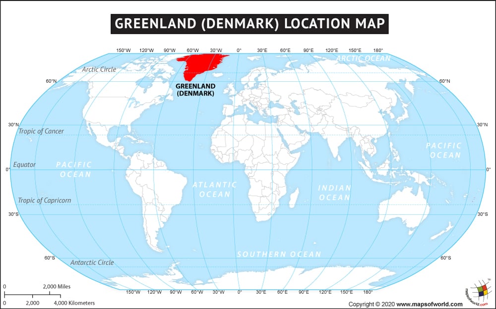
Greenland, the world’s largest island, is a self-governed province under the control of Demark. Denmark controls the overseas affairs of Greenland in consultation with the Home Rule Government of the island. The geographic coordinates of Greenland are 72° North latitude and 40° West longitude. Greenland is located on the north side of North America. The island lies between North Atlantic Ocean and the Arctic Ocean. Greenland’s total area is 2,166,086 square kilometers. The island has 44,087 kilometers of coastline. The lowest point of the island is 0 meters and the highest point is 3700 meters.
Greenland Capital
The capital of Greenland is Nuuk. It is also the largest city in Greenland. The University of Greenland is located in the capital city and Air Greenland offers regular flight service to Nuuk Airport. Moderate polar climate prevails at Nuuk. The geographic coordinates of Nuuk are 64° 10′ 60″ North latitude and 51° 45′ West longitude. Nuuk is positioned 3 meters above sea level. Some of the cities that are in close proximity to Nuuk are Saarloq, Kangeq, and Narsaq. The capital of Greenland is highlighted on the political map Greenland with a red star.
Greenland Cities
In the printable map of Greenland, the major cities have been indicated by using black dots. The indicated cities in Greenland are:
|
|
Greenland Borders
Canada is located on the western side of Greenland. In the political map of Greenland, the international boundaries have been indicated by using black lines. The bordering water bodies of Greenland as indicated in the political Greenland map are:
- Atlantic Ocean: southeast
- Denmark Strait: southeast
- Davis Strait: west
- Baffin Bay: west
- Greenland Sea: east
- Lincoln Sea: north
- Arctic Ocean: north
Greenland Locations
In the political printable map of Greenland, few other locations like Disko Island and Kap Bridgman have been indicated. The Thule Air Base is also indicated on the political Greenland map by a red airplane and a black circle around the figure.
The country of Greenland is on the North American continent and the latitude and longitude of the country are 72° N and 40° W.
The neighboring countries of Greenland are :
Maritime Boundaries
Facts About Greenland |
|---|
| Country Name | Greenland |
|---|---|
| Continent | North America |
| Capital and largest city | Nuuk |
| Area | 2,166,086 km2 (836,109 sq mi) |
| Population | 56,980 estimated |
| Lat Long of Greenland | 72° 0′ 0″ N, 40° 0′ 0″ W |
| Official Language | Greenlandic (Kalaallisut) |
| Calling Code | +299 |
| Time Zone | (UTC+0 to −4) |
| Airports in Greenland | 14-Airports Commercial Service |
| Neighbour Countries | Norway, Denmark, Iceland |
| Internet TLD | .gl |
| Currency | Danish krone (DKK) |

 Greenland Education System