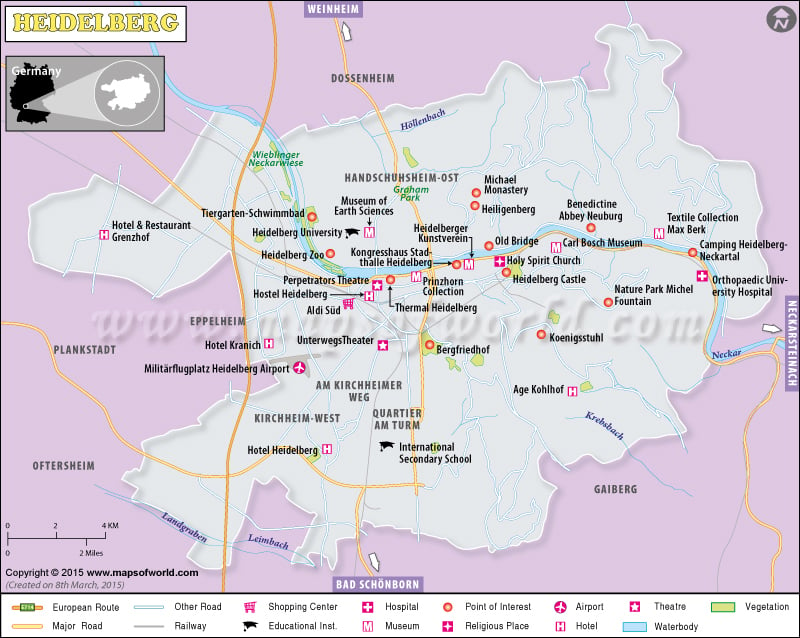
Located in 49° 25′ N, 8° 43′ E, Heidelberg Germany , lay in south western state of Baden-Württemberg. The approximate population of Heidelberg is 148,415 which neighbors the Rhein Neckar Kreis region and is often called Heidelbeerenberg or the Blueberry Mountain region of Germany(German: Deutschlandkarte). The city is commercially rising with industries of tourism, printing, and publishing.
The topography of Heidelberg Germany is made of the narrow, steep valley of Odenwald that flows into the Rhine valley, 20 km northwest of the town, and joins the Rhine at Mannheim. The city is divided into 14 districts :
- Central area comprises of Altstadt, Bergheim, and Weststadt.
- In the north: Neuenheim and Handschuhsheim.
- East composed of Ziegelhausen and Schlierbach.
- Southern part circumscribes Südstadt, Rohrbach, Emmertsgrund, and Boxberg
- The west is made of Bahnstadt, Pfaffengrund, and Wieblingen.
- And in the Southwest is lays the Kirchheim.
Some of the attractive places and spots for travelers and tourists while in Heidelberg Germany are:
Heidelberg Castle, a blend of gothic to renaissance style architecture, was built by Prince Elector Ruprecht III in the 14th century. The building is designed with stone-made ground floors and framework upper levels. The castle is encircled by a park that was once strolled by poet Johann von Goethe.
Ruprecht Building – The Fountain Hall is used for different kinds of festivals and occasions like dinner banquets, balls, and theatre performances. In summer, the Heidelberg Castle Festival is held in courtyards with open-air musicals, operas, theatre performances, and classical concerts.
Heidelberger Bergbahn funicular railway is another notable feature of the city that runs from Heidelberg’s Kornmakt to the summit of the Königstuhl.
Heidelberg University is one of the oldest institutions in Europe. The city of Heidelberg is also the home to The European Molecular Biology Laboratory, European Molecular Biology Organization, The German Cancer Research Center, and several Max Planck Institutes – the Max Planck Institute for Medical Research, the Max Planck Institute for Astronomy, the Max Planck Institute for Nuclear Physics and the Max Planck Institute for Comparative Public Law and International Law.
There are events all around the year like:
- “Ball Der Vampire” or the Ball of the Vampires is held in February
- “Heidelberger Frühling” Classic Music Festival is held in March/April
- The half marathon is held on the last weekend of April.
- Frühlingsmesse on the Messplatz is held in May
- Heidelberger Theater Days, “Enjoy Jazz”, Stepdance Festival, and Workshops are in October/November.
- International Filmfestival Mannheim-Heidelberg is also celebrated in November.
Heidelberg Germany earns global prominence through international relationships with Montpellier, France, Cambridge, United Kingdom, Rehovot, Israel, Simferopol, Ukraine, Bautzen, Saxony, and Kumamoto, Japan.
Climate Data for Heidelberg |
| Month | Jul | Aug | Sep | Oct | Nov | Dec | Year |
|---|---|---|---|---|---|---|---|
| Average high °C (°F) | 25.5 (77.9) | 25.1 (77.2) | 21.5 (70.7) | 15.3 (59.5) | 8.5 (47.3) | 4.8 (40.6) | 15 (59.0) |
| Daily mean °C (°F) | 20.6 (69.1) | 20.1 (68.2) | 16.1 (61) | 11.5 (52.7) | 6.3 (43.3) | 3.3 (37.9) | 11.4 (52.5) |
| Average low °C (°F) | 14 (57.2) | 13.8 (56.8) | 10.6 (51.1) | 6.7 (44.1) | 2.4 (36.3) | −0.4 (31.3) | 6.1 (42.9) |
| Average precipitation mm (inches) | 71 (2.8) | 66 (2.6) | 53 (2.1) | 58 (2.3) | 66 (2.6) | 66 (2.6) | 770 (30.3) |
| Mean monthly sunshine hours | 233 | 219 | 157 | 101 | 50 | 35 | 1631 |
