- Neighboring Countries - Russia, Turkiye, Armenia, Azerbaijan
- Continent And Regions - Europe Map
- Other Georgia Maps - Georgia Map, Where is Georgia, Georgia Blank Map, Georgia Road Map, Georgia Rail Map, Georgia River Map, Georgia Cities Map, Georgia Physical Map, Georgia Flag
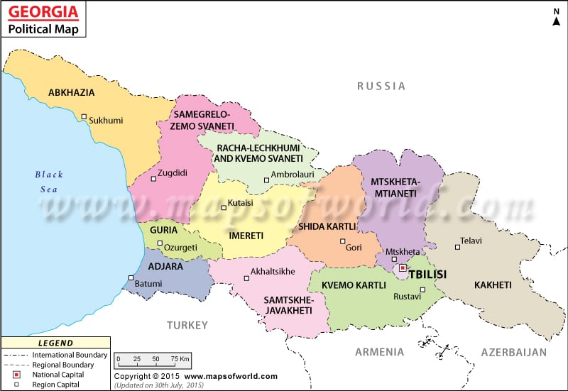
Georgia is a Eurasian country and in the political map of Georgia, the administrative divisions of the country have been indicated in a clear format by using different symbols. Tbilisi is the capital of Georgia, which is also the largest city in Georgia. The capital city is highlighted in the printable map of Georgia.
Political Georgia Map
Georgia is located in southwest Asia and is a Eurasian country. Georgia’s location is at the border of western Asia and Eastern Europe. Georgian is the official language of the country. The geographic coordinates of Georgia are 42° North latitude and 43° 30′ East longitude. The total area of the country is 69,700 square kilometers. The population of the country as per the census of July 2007 was 4,646,003. Georgia experiences a warm and pleasant climate. In the northern part of the country, there is the Great Caucasus and in the southern half, there is Lesser Caucasus Mountains.
Georgia Capital
The capital of Georgia is T’bilisi. The republic capital is highlighted in the political Georgia Map by a red square having a black border. The capital of the country also happens to be the largest city in Georgia. The city is visited by a large number of tourists. Tbilisi is positioned in South Caucasus. The geographical coordinates of Tbilisi are 41° 43′ 30″ North latitude and 44° 47′ 27″East longitude. The city is 1482 feet above sea level. Some of the airports that are in close proximity to Tbilisi are:
- Lochini
- Tbilisi Marneuli
- Tbilisi Soganlug
- Vaziani
Some of the nearby cities of Tbilisi are Saburtalo to the western side, Vazisubani to the east, Vashladzhvari and Grmagele to the north, and Zemo T’elet’I and Okrokana to the south.
Georgia Boundaries
The international boundaries of Georgia are indicated in the printable map of Georgia by a specific pattern of black lines. The countries that border Georgia is:
- Turkey: south of Georgia
- Azerbaijan: to the east
- Armenia: on the south
- Russia: on the northern side
The main water body that forms the border of the country on the western side is the Black Sea, which is also indicated in the political map of Georgia.
Georgia Administrative Divisions
On Georgia’s political map, the Autonomous Republic centers of Batumi and Sukhumi have been indicated by using white boxes. The Autonomous Oblasts Center of Georgia is Tskhinvali, which is highlighted in the printable Georgia political map by using a black dot.
The nine administrative regions in Georgia are:
- Imereti
- Guria
- Kvemo Kartli
- Kakheti
- Racha-Lechkhumi and Kvemo Svaneti
- Mtskheta-Mtianeti
- Samtskhe-Javakheti
- Samegrelo and Zemo Svaneti
- Shida Kartli
| Region | Population | Area(km.²) | Area(mi.²) | Capital |
|---|---|---|---|---|
| Abkhazia | 1,956 | 88 | 34 | Sokhumi |
| Ajaria | 376,016 | 2,900 | 1,120 | Batumi |
| Guria | 143,357 | 2,033 | 785 | Ozurgeti |
| Imereti | 699,666 | 6,552 | 2,530 | Kutaisi |
| Kakheti | 407,182 | 11,310 | 4,367 | Telavi |
| Kvemo Kartli | 497,530 | 6,528 | 2,520 | Rustavi |
| Mtskheta-Mtianeti | 125,443 | 6,786 | 2,620 | Mtskheta |
| Racha-Lochkhumi-Kvemo Svaneti | 50,969 | 4,954 | 1,913 | Ambrolauri |
| Samegrelo-Zemo Svateni | 466,100 | 7,442 | 2,873 | Zugdidi |
| Samtskhe-Javakheti | 207,598 | 6,413 | 2,476 | Akhaltsikhe |
| Shida Kartli | 314,039 | 4,808 | 1,856 | Gori |
| Tbilisi | 1,081,679 | 244 | 94 | Tbilisi |
| 12 divisions | 4,371,535 | 60,106 | 23,207 |
 Wall Maps