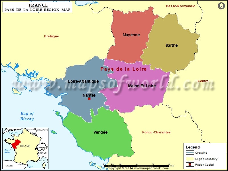
Pays de la Loire Map

PAYS DE LA LOIRE The French Metropolitan Region of Pays de la Loire was created in the late 20th century. The purpose of creating this region was that this region would serve as a hinterland and a zone of influence for the capital, Nantes. Rhone-Alpes is another artificially created region. It was created as a region for Lyon and Mide-Pyrenees.
The capital of Pays de la Loire region is Nantes. This region is divided into five departments. These are Loire-Atlantique, Mayenne, Maine-et-Loire, Sarthe and Vendee. This region is divided tinto 17 arrondissements, 192 cantons and 1,503 communes. The total area covered by this region is 32,082 km2.
This region is made up of a number of historical provinces. 20% of Brittany is a part of Pays de La Loire. The remaining 20% of Brittany is part of Bretagne region. The entire former provinces of Anjou and Maine are a part of Pays de la Loire region. A small section of Poitou, a part of Perche and Touraine are a part of Pays de la Loire region.
Hence, the name of the region was based on geographical references. Pays means “lands” and de la Loire means “of the Loire River”. It worth noting that the world famous Chateaux of the Loire Valley is not located in this region. Infact, it is located in the Centre region.
Loire River cuts this river from east to west. This region is proud of its rich heritage and has been declared a World heritage for Humanity Site by UNESCO.
The region has a long coast on the Bay of Biscay to the west. Brittany borders the region towards the north and west. Lower Normandy borders the region towards the north. Centre is located towards the east of the region and Poitou-Charentes is located towards the south.
On the Atlantic Coast, numerous fishing and shipping ports are there. Some minerals that are mined from Pays de la Loire region are Iron and Uranium. The industries here produce motor vehicles, ships and textiles.