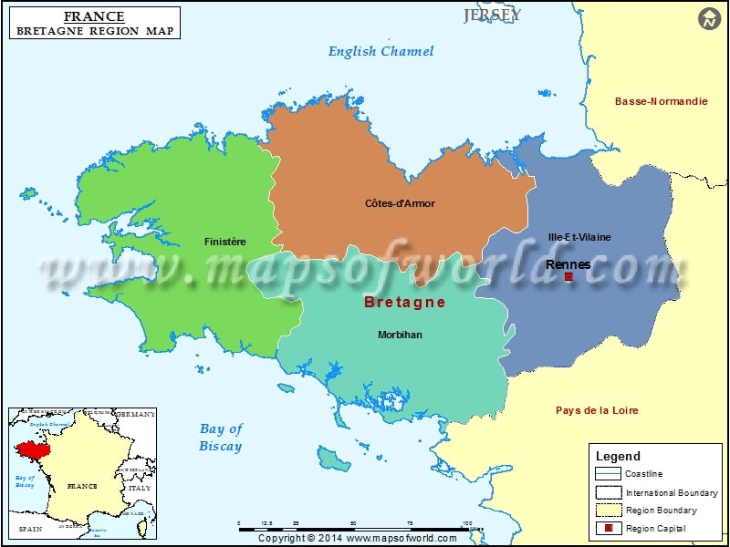
Brittany (Bretagne) France Map

BRETAGNE (BRITTANY)
Bretagne is one of the 26 regions of France. Bretagne is also known as Brittany. Bretagne occupies a large peninsula in the northwest of France. English Channel is located on the North of Bretagne and Bay of Biscay is located on the south. Rennes is the capital city of the French Metropolitan City of France. Cotes-d’Armor, Ille-et-Vilaine, Morbihan and Finistere are the departments of Bretagne. The region is made up of 15 arrondissements, 201 Cantons and 1,268 Communes.
TERRITORY OF BRETAGNE
Around 80% of Bretagne is made up of former duchy and province of Brittany. The remaining 20% of Brittany is made up of the Loire-Atlantique departement. This departement lies within the Pays-de-la-Loire region.
There’s a reason behind the splitting of Brittany into two modern day regions. This was done to avoid rivalry between Rennes and Nantes. Nantes was the main capital of the duchy of Brittany till the 16th century. Rennes functioned as the seat of the parlement of Brittany between 1560 and 1789. Earlier Rennes was also the administrative capital of the intendance of Brittany. The “Chambre des comptes” was in Nantes till 1789. It’s worth noting that Vannes, was the first administrative capital of Duchy from 1381 till the end of 15th century. The total area covered by Bretagne is 27,209 square kilometers.
LANGUAGE OF BRETAGNE
In Bretagne, two regional languages namely Breton and Gallo are recognized. Breton is spoken in the western part of Brittany.
TRANSPORTATION OF BRETAGNE
In the French Metropolitan Region of France, you would find several airports. These airports served destinations in France and England. The region has TGV train services that link it with cities of other regions such as Paris, Lyon, Marseille and Lille. Ferry services for commuting to Ireland, England and the Channel Islands are also available.