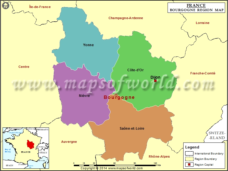
Bourgogne Region Map

View detailed world maps that offer a global perspective—political, physical, and more.
Explore maps that visualize data on topics like population, climate, economy, and beyond.
Navigate the world with maps that guide your journeys—country and city maps for travelers.
Learn, discover, and share with educational maps, geography trivia, and cartographic insights—ideal for classrooms and curious minds.
FBrowse quick-reference lists for airports, area codes, capitals, postal codes, time zones, and more—organized for easy access.
Explore powerful mapping tools and services.
Order custom maps tailored to your most specific needs, whether for business, education, travel, or more!
Learn moreView detailed world maps that offer a global perspective—political, physical, and more.
Explore maps that visualize data on topics like population, climate, economy, and beyond.
Navigate the world with maps that guide your journeys—country and city maps for travelers.
Learn, discover, and share with educational maps, geography trivia, and cartographic insights—ideal for classrooms and curious minds.
FBrowse quick-reference lists for airports, area codes, capitals, postal codes, time zones, and more—organized for easy access.
Explore powerful mapping tools and services.

The French Metropolitan Region of Bourgogne is one of the 26 regions of France. The capital of this region is Dijon. Dijon is famous as a gastronomic center. The departments of this region are Yonne, Cote-d’Or, Nievre and Saone-et-Loire. The region has around 15 arrondissements, 174 cantons and 2,045 communes. The total land area covered by this region is 31,582 square kilometers.
Bourgogne is made up of a number of old provinces.
This historic region is located in East Central France. The fertile Rhone and Saone River Valleys are an integral part of this region. Burgundy’s wine is popular across the world. The wine of the Cote d’Or (“Golden Slope” ) has enjoys great popularity.
Under the Roman rule, the region prospered tremendously. By the 5th century, the Burgundii, a Germanic tribe settled in this region. It was a part of the Frankish kingdom under Merovingians in 534 AD. Later in 751 Ad, it became a part of the Carolingians.
In 9th century, after the partition of the Carolingian Empire, two Burgundian states were formed. These were Lower Burgundy (Provence and Upper Burgundy.
Later the duchy of Burgundy and the free County of Burgundy were formed.
Burgundy (Bourgogne) Railway Map shows the railway lines, major towns of the region, the regional boundary, and regional capital.
Burgundy (Bourgogne) Road Map shows the major roads, highways, major towns of the region, the regional boundary, and regional capital.
We rely on ads to keep creating quality content for you to enjoy for free.
Please support our site by disabling your ad blocker.
If the prompt is still appearing, please disable any tools or services you are using that block internet ads (e.g. DNS Servers).