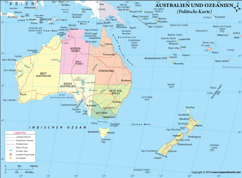
Die auf der Landkarte eingezeichneten Orte
Ozean, Meer & Golf:
Arafurasee, Bandasee, Bass-Strabe, Golf Von Carpentaria, Indischer Ozean, Korallenmeer, Sudpazifik, Tasmanische See, Timorsee, Torresstrabe
Nachbarkontinente:
Asien
Inselgruppe:
Inselstaat |
Hauptstadt |
Wichtigste Inseln |
| AMERIKANISCH-SAMOA | Pago-Pago | – |
| AUSTRALIEN | Canberra | Lord-Howe-Ins. (Aust.) Norfolkinsel (Aust.) Weihnachtsinsel (Aust.) |
| COOKINSELN (N.S.) | Rarotonga | Atiu Mangaia Manihiki Nassau Penrhyn (N.S.) Pukapuka Rakahanga |
| FIDSCHI | Suva | Vanua Levu Viti Levu |
| FRANZOSISCH-POLYNESIEN | Papeete | Austral-Inseln Fatu Hiva Gambier-inseln Gesellschaftsinseln Hiva Oa Marotiri Marquesasinseln Nuku Hiva Puka-Puka Ra’iatea Rapa Iti Tahiti Tuamotu-Archipel |
| KIRIBATI | Bairiki | Banaba Caroline Enderbury Flint Gilbertinseln Malden McKean Nikumaroro PhOnixinseln Starbuck Vostok |
| NAURU | Yaren | – |
| NEU-KALEDONIEN (Fr.) | NoumEa | Chesterfield Huon Loyalitatsinseln |
| NEUSEELAND | Wellington | Antipoden-Inseln (N.S.) Bountyinseln (N.S.) Kermadecinseln (N.S.) Stewart |
| PAPUA-NEUGUINEA | Port Moresby | Bougainville Manus Neubritannien Neuirland |
| PITCAIRN-INS. (GB) | Adamstown | Henderson Oeno Pitcairn |
| SALOMONEN | Honiara | Guadalcanal Malaita Santa-Cruz-Inseln |
| TOKELAU (N.S. ) | – (jedes Atoll hat ihren eigenen Verwaltungssitz) | Atafu Fakaofo Nukunonu Swains |
| TONGA | Nuku’alofa | Ata Niue (N.S.) Tafahi |
| TUVALU | Funafuti | Funafuti Nukulaelae |
| VANUATU | Port Vila | EfatE Espiritu Santo Malekula |
| WALLIS & FUTUNA (Fr.) | Mata-Utu | – |
| WEST-SAMOA | Apia | – |
Information uber Kontinent Australien |
|
| Flache | 8.560.000 km2 (ca. 5.2% der Landmasse der Erde) |
| BevOlkerung | etwa 28,4 Millionen |
| HOchster Punkt | Puncak Jaya (4.884 m) |
| Niedrigster Punkt | Lake Eyre (-15 m) |
| Langster Fluss | Darling (2.739 km) |
| GrObter See | Lake Eyre (9.500 km2) |
| GrObtes Land | Australien: 7.692.030 km2 |
| Kleinstes Land | Die Republik Nauru: 21,30 km2 |

 Welt Umrisskarte