- Denmark Cities - Aalborg, Copenhagen, Odense
- Neighboring Countries - Germany, Poland, Norway, Sweden
- Continent And Regions - Europe Map
- Other Denmark Maps - Denmark Map, Where is Denmark, Denmark Blank Map, Denmark Road Map, Denmark River Map, Denmark Physical Map, Denmark Flag, Denmark Time Zone
Denmark is a Scandinavian country located in northern Europe. The country covers a total area of 1,370,000 square miles. According to the 2011 census, the country had an estimated population of 5,671,050.
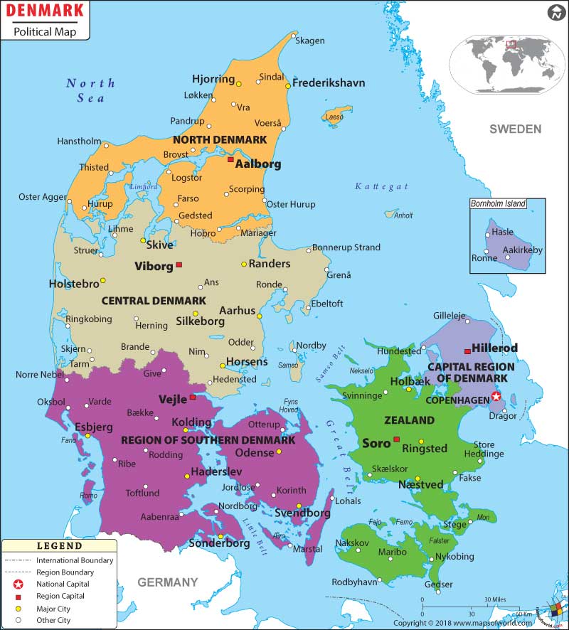
As shown in the Denmark Political Map, Denmark is the southern-most of the Nordic countries. It is bordered by Sweden to the south-west, Norway and Germany to the south. The country also borders both the Baltic and the North Sea.
The Kingdom of Denmark comprises Denmark, Greenland, and the Faroe Islands.
The Denmark Political Map shows the national capital, major cities, regions, counties, and other political divisions of the country. The international boundaries of the country are also shown in the map.
Copenhagen is the capital city of Denmark and is marked in the map with a red dot enclosed in a square. With an urban population of 1,199,224, it is the largest city in the country. It is the major cultural, administrative, and scientific center of Denmark. Copenhagen is one of the most eco-friendly cities in the world.
The other major cities of Denmark are: Copenhagen, Aarhus, Odense, Randers, Kolding, Vejle, Fredericia, Haderslev, Silkeborg, and Viborg.
For administrative purposes, Denmark is divided into five regions and ninety-eight municipalities. The regions are:
- Capital Region of Denmark
- Central Denmark Region
- North Denmark Region
- Region Zealand
- Region of Southern Denmark
The Central Denmark Region is the largest area in the country.
The Kingdom of Denmark is a unitary parliamentary democracy and a constitutional monarchy wherby the Prime Minister is the head of the government and the Monarch is the head of state.
Presently, Helle Thorning-Schmidt is the Prime Minister of Denmark and Margrethe II is the Monarch.
Countries of Denmark |
| County | Capital | Population – 2001 census | Area(km.²) |
|---|---|---|---|
| Arhus | Arhus | 640,637 | 4,561 |
| Bornholm | Ronne | 44,126 | 588 |
| Copenhagen | Copenhagen | 615,115 | 526 |
| Copenhagen City | Copenhagen | 499,148 | 88 |
| Frederiksberg | Frederiksberg | 91,076 | 9 |
| Frederiksborg | Hillerod | 368,116 | 1,347 |
| Fyn | Odense | 472,064 | 3,486 |
| North Jutland | Alborg | 494,833 | 6,173 |
| Ribe | Ribe | 224,446 | 3,131 |
| Ringkobing | Ringkobing | 273,517 | 4,853 |
| Roskilde | Roskilde | 233,212 | 891 |
| South Jutland | AbenrA | 253,249 | 3,938 |
| Storstrom | Nykobing (Falster) | 259,691 | 3,398 |
| Vejle | Vejle | 349,186 | 2,997 |
| Vestsjelland | Soro | 296,875 | 2,984 |
| Viborg | Viborg | 233,921 | 4,122 |
| Region | Population: 2005-01-01, according to Danmarks Statistik. | Area(km.²) | Area(mi.²) | Capital | Danish | Former |
|---|---|---|---|---|---|---|
| Capital | 1,631,635 | 2,561 | 989 | Hillerod | Hovedstaden | BO, FR, KH, SF, SK |
| Central Jutland | 1,212,787 | 13,053 | 5,040 | Viborg | Midtjylland | AR, RK, VB (part), VJ (part) |
| North Jutland | 577,278 | 8,020 | 3,097 | Aalborg | Nordjylland | NJ, VB (part) |
| Zealand | 805,954 | 7,273 | 2,808 | Soro | Sjaelland | RS, ST, VS |
| South Denmark | 1,183,751 | 12,191 | 4,707 | Vejle | Syddanmark | FY, RB, SJ, VJ (part) |
| 5 regions | 5,411,405 | 43,098 | 16,640 |
