- DRC Cities - Kinshasa
- Neighboring Countries - Angola, Republic of the Congo, Central African Republic, South Sudan, Uganda, Rwanda, Burundi, Tanzania, Zambia
- Continent And Regions - Africa Map
- Other Democratic Republic of the Congo Maps - DRC Map, Where is DRC, DRC Blank Map, DRC Road Map, DRC Rail Map, DRC River Map, DRC Physical Map, DRC Flag
Major Provincial Locations
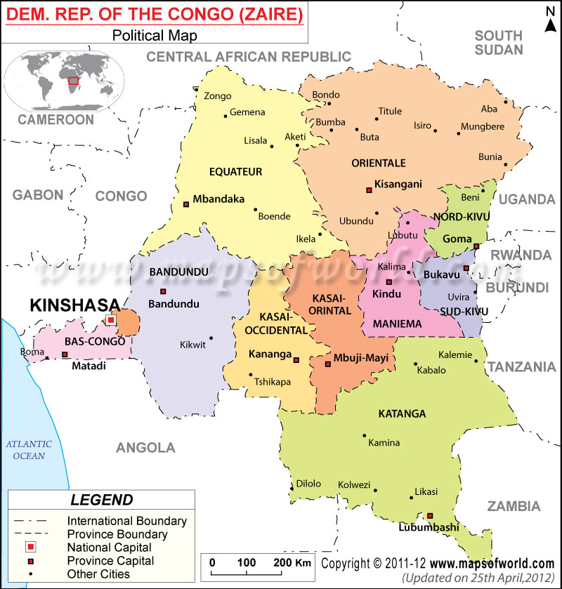
Equateur, Orientale, Bandundu, Kasai-Oriental, Maniema, Sud-Kivu, Nord-Kivu, Kasai-Occidental, Katanga, Kinshasa.
Major Province Capitals
Mbandaka, Kisangani, Goma, Kindu, Bukavu, Bandundu, Kananga, Mbuji-Mayi, Lubumbashi.
Other Major Cities
Zongo, Gbadolite, Mobayl-Mbongo, Gemena, Lisala, Bumba, Boende, Ikela, Bondo, Buta, Aketi, Titule, Isiro, Mungbere, Bunia, Mambasa, Ubundu, Kalima, Shabunda, Fizi, Kalemie, Kabalo, Kamina, Tshikapa, Kikwit, Kolwezi, Likasi, Dilolo, Mbanza-Ngungu, Boma, Tshela.
Oceans, Seas, River, Bays, and Canals
The Atlantic Ocean.
Neighbour Countries/Islands
Cameroon, Central African Republic, South Sudan, Congo, Gabon, Uganda, Rwanda, Burundi, Tanzania, Angola, and Zambia.
Democratic Republic of Congo’s political map marks the provincial and international boundary of the African country for the convenience of web surfers. The printable map of the Democratic Republic of Congo marks the different provinces of the Democratic Republic of Congo with individual colors and bold fonts used to name the provinces and their capitals. The country capital can be easily found for its red dot and the provincial capitals are marked with white squares.
Democratic Republic of Congo political map
is helpful for web surfers. The political map of the Democratic Republic of Congo displays the provincial boundaries of the country with their capitals and important cities, which are located across this African country. The printable map of the Democratic Republic of Congo marks the provincial boundaries with broken lines while the international boundary is marked with dotted broken lines in black.
Geography of the Democratic Republic of Congo
According to the world map, the Democratic Republic of Congo lies at 1º South of the Equator and 15º East of the Prime Meridian. The country is located in the western part of the African continent. The country shares its border with Tanzania, Angola, Zambia, Burundi, Rwanda, Uganda, Sudan, Cameroon, and the Central African Republic. The total area covered by the Democratic Republic of Congo is 342,000 square kilometers, of which land area is 341,000 square kilometers and 500 square kilometers is covered by water. The coastline of the Democratic Republic of Congo stretches over 169 kilometers. Mont Berongou is the highest point with 903 meters altitude, while the Atlantic Ocean is the lowest point. The country is inhabited by around 3,039,126 people.
Country Capital
The capital of the Democratic Republic of Congo is Kinshasa. The geographical extent of Kinshasa is 4º18′ South and 15º18′ East. It is the largest city in the country and is marked with a red dot within a square. The total area of this densely populated city is 9,965 square kilometers. The city stands on the south bank of the Congo River. Kinshasa is both a province and a city, which is divided into 24 municipalities or communes.
Province Boundaries and their Capitals
The map of the Democratic Republic of Congo shows the 11 provincial boundaries colored individually, which together form the Democratic Republic of Congo. The provincial capitals are marked with white squares. The name of the provinces and their capitals are listed below:
|
|
|
|
|
|
|
|
|
|
|
Important Cities
Some of the important cities marked in the Democratic Republic of Congo map are as follows:
|
|
|
|
|
|
|
|
|
|
|
|
|
|
|
|
|
|
|
|
|
|
|
|
|
|
||||||||||||||||||||||||||||||||||||||||||||||||||||||||||||||||||||||||||||||||||||||||||||||||||||||||||||
|

 DRC Facts