Comoros

- Comoros Cities - Moroni
- Continent And Regions - Africa Map
- Other Comoros Maps - Where is Comoros, Comoros Blank Map, Comoros Road Map, Comoros Flag
About Comoros
Explore this Comoros map to learn everything you want to know about this country. Learn about Comoros location on the world map, official symbol, flag, geography, climate, postal/area/zip codes, time zones, etc. Check out Comoros history, significant states, provinces/districts, & cities, most popular travel destinations and attractions, the capital city’s location, facts and trivia, and many more.
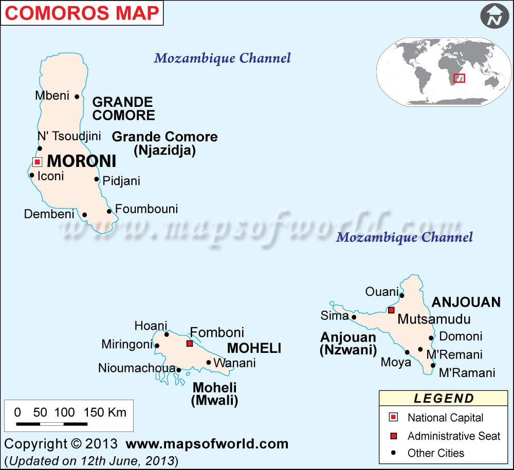
Officially recognised as the Union of the Comoros, the Islamic Federal of Comoros derieved its present name from the Arabic term “Qamar” which means moon. Mainly a three island group constitution which includes the islands of Mwali, Njazidja and Nzwani that has its own charm and cultural significance. The capital city of this region is Moroni where the local native speaks the official Arabic and French languages.
People Of Comoros
The native people of Comoros come from the African-Arab origin where the majority of the population constitutes of Grande Comore, Anjouan, and Moheli. The Arabic culture is predominantly established here with Islam being the main religion. Only a minor group of community in Mayotte are Catholics molded by the French culture. A small group of Creole-speaking folks even derieve from Reunionnaise. The resident language of this place includes the dailect of Shikomor, French, Arabic, Malagasy and Latin. It was mainly the traders from the Arab region, the immigrants from the Malay and the African natives that contributed to the cultural bondage of this place.
Physical Map Of Comoros
The land of Comoros was constituted with one of the four islands namely Mwali, Njazidja and Nzwani out of which the fourth one being the Mayotte, popularly a French territory. This volcanic island is covered with steep mountain hills to low lying areas.
Two volcanoes form the largest land of Njazidja, especially La Grille towards the north and Kartala towards the south that boasts of extensive rain forest.
Find three major peaks namely Sima, Nioumakele, and Jimilime in the land of Nzwani where shorelines are covered with coral reefs. Mahoré that boasts of several islet and which is supposedly the oldest among the other islands, where soil is quite fertile due to volcanic rock weathering.
Location Of Comoros
Comoros is nestled within the Indian Ocean, near the northern end of the Mozambique Channel lying in the midst of northern Madagascar and Mozambique that lies towards the northern zone.
Flag Of Comoros
The Flag of Comoros came into existence during the year of 2003. The initial flag was slightly different from the present one. The present one retains the crescent of the previous flag and rests on a green triangle. The four stripes in the flag represents the four main island of this region where the color yellow describes Moheli, the white is branded for Mayotte, the red is for Anjouan and the color blue describes Grand Comore. The crescent here signifies the Islamic religion of Comoros and the four stars depict the importance of island itself.
Climate Of Comoros
Comoros is an example of what is known for having a typical maritime tropical ambience. Nestled towards the south of equator, which comprises of both humid wet climatic condition to cooler dry season. Bear with the sultry climate, which can be felt from the month of November to April and enjoy the chilly breezy windy atmosphere from the months of May and October. Temperature averages out from 78 degree Fahrenheit to 86 degree Fahrenheit during the spell of rainy season. The areas are frequently affected by cyclones and tidal waves that hit the place.
Flora And Fauna Of Comoros
The volcanic soils of Comoros encourage the expansion of innumerable foliage within its forest zone that boasts of plants like coconut palms, mangoes, broom, lichens, bananas and several other tropical hardwoods.
Come across a rarest kind of fish in Comoros, which is known as coelacanth that possess a limblike fins and a cartilaginous skeleton that was considered extinct once upon a time.
This desert region has very little expanses of greenery that can be seen in the basalt areas of northern region. Moheli is the known as the smallest among the Comorian Island, which is a home to several rare species.
Mohéli Marine Park or Moya-Papani, Mayotte is known for reserving special sea birds or tropical birds and is a nesting spot for turtles .
Arts, Culture And Music Of Comoros
The wedding ceremony in this place is a preplanned affair between a man and women where the men bears all the cost for the celebration while feasting the entire village during this occasion. It is the groom who purchases dowry for the bride along with precious possessions. The local women are found to apply facemask in different patterns made from sandalwood or a yellowish paste.
The music of Comoros made its entry to this region with major melodic influences from the East Africa, the Middle East, Madagascar, and southern India. The traditional instruments that were popularly used were gongs, drums, tambourines, rattles, oboes, zithers, and five-stringed lutes. The musical genre that became popularly recognized was Zanzibar’s taarab music and sega music from Mauritius and Reunion Island.
Economy Of Comoros
Though considered as the poorest country in the world, the present economic status of this place depends mainly on agriculture, fishing, hunting and forestry. The agricultural industry has its contribution to about 40% of GDP, where major portion is exported. The place is known for its largest productions in vanilla, perfume essence, cloves and ylang-ylang, which is a tropical Asian tree from the pineapple kin . All the efforts are been made from the government end to improvise on education and technical training, commercial enterprises, health services, tourism industry, and population growth rate. The inhabitants of Comoros are depended mainly on foreign aid.
Stay connected at Mapsofworld for all relevant information about the Comoros Island.