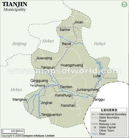
Map of Tianjin Province of China

View detailed world maps that offer a global perspective—political, physical, and more.
Explore maps that visualize data on topics like population, climate, economy, and beyond.
Navigate the world with maps that guide your journeys—country and city maps for travelers.
Learn, discover, and share with educational maps, geography trivia, and cartographic insights—ideal for classrooms and curious minds.
FBrowse quick-reference lists for airports, area codes, capitals, postal codes, time zones, and more—organized for easy access.
Explore powerful mapping tools and services.
Order custom maps tailored to your most specific needs, whether for business, education, travel, or more!
Learn moreView detailed world maps that offer a global perspective—political, physical, and more.
Explore maps that visualize data on topics like population, climate, economy, and beyond.
Navigate the world with maps that guide your journeys—country and city maps for travelers.
Learn, discover, and share with educational maps, geography trivia, and cartographic insights—ideal for classrooms and curious minds.
FBrowse quick-reference lists for airports, area codes, capitals, postal codes, time zones, and more—organized for easy access.
Explore powerful mapping tools and services.

Tianjin is one of the municipalities in China and is a province, it is directly under the central government. Tianjin is China’s third largest city as per the area.
To the east of Tianjin province lies the Bohai Gulf, Beijing is to the northwest of Tianjin and the border of Hebei encircles the north, south and west side of Tianjin. The civilization here in Tianjin conglomerates around the bank of the river Hai He.
The place where Tianjin lie today was created due to the sedimentation of many rivers that passed through this area while on their way to the sea. With the opening of Grand canal, Tianjin came to the forefront as a trading center. Grand canal lies to the north of Tianjin and connects the Yangtze and the Hwang Ho river.
Tianjin is a flat plane and a swampy area except for the northern part which is hilly because of the Yanshan Mountains. Jiushanding Peak is the highest peak in Tianjin with an altitude of 1078 meter. The confluence of Yongdinh river, Ziya river, Daqing riber and the north and south grand canals forms the Hai He river . There are two main reservoirs in the extreme north and extreme south Tianjin, Yuqiao Reservoir in the north and Beidagang Reservoir in the south.
The climate of Tianjin is hot and humid during the summer and dry and cold during the winter. Rainfall occurs mainly during the summer. Siberian anti-cyclones enters the region during the winter. Sandstorms occurs quite often which has its origin in the Gobi Desert.
Tianjin is a beautiful scenic spot of China. It is situated beside the Hai He River. and is one of the four municipalities of the People’s Republic of China. it has gained provincial-level…
Tianjin Outline Map showing the blank map of Tianjin province of China for free download, printouts, and for educational purposes.
Tianjin Road Map shows all the major roads and highways in Tianjin province of China. The Map shows the province boundary and Capital.
Tianjin Tourism is one of the richest and the most prosperous business center of China. Being close to Bohai Sea and Beijing, the capital city of People’s Republic of China, Tianjin…
Tianjin is one the four municipalities of China. Based on its historical background it has been nicknamed “Shanghai of the North”. The specialties of Tianjin are large port, heavy industrial output and European architecture style.…
We rely on ads to keep creating quality content for you to enjoy for free.
Please support our site by disabling your ad blocker.
If the prompt is still appearing, please disable any tools or services you are using that block internet ads (e.g. DNS Servers).