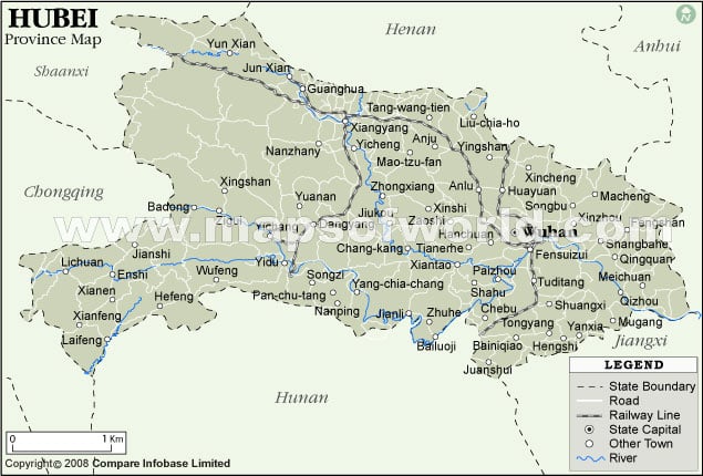
Hubei Province Map

Hubei is an important province of the People’s Republic of China . Hubei is known as the Province of a Thousand Lakes. Hubei literally means North of Lake, a reference to nearby Lake Dongting.
Also referred popularly as Chu, after the historic state of Chu said to have existed during the reign of the Eastern Zhou Dynasty (1121 to 222 BC). Locals often refer to Hubei as E for short. Wuhan is the capital of the province.
With an area of 185,900 sq.km, the province of Hubei lies in Central China, across two important rivers, the Yangtze and the Hanjiang. Hubei is bordered by the provinces of Henan in the north, Anhui on the east, Jiangxi and Hunan on the south, Chongqing Municipality on the west and Shaanxi on the northwest.
Important Cities in Hubei Province are –
- Wuhan
- Jingmen
- Shiyan
- Shashi.
Administrative Divisions of Hubei
Hubei is divided into the following Administrative Divisions
- 1 autonomous prefecture of Enshi Tujia and Miao
- 12 prefecture-level cities
- 24 county-level cities
- 39 counties
- 2 autonomous counties
- 1 forest district of Shennongjia
While Wuhan is categorized under the Semi Provincial Administration, the cities of Tianmen, Qianjiang and Xiantao are under direct county administration.
Early History about Hubei
Earlier known as Chu, Hubei was the seat of power of the Zhou Dynasty. During 475 to 221 BC, Chu was involved in many battles with the neighboring state of Qin, now Shaanxi Province. Chu gradually lost most of its territories to the Qin. The Qin were then deafeated by the Han, who established their capital in erstwhile Jingzhou, now the area occupied by Hubei and Hunan. Through the years, Hubei was occupied by successive dynasties. The Song Dynasty renamed the Province to Jinghubei in 982. In 1339, the Mongols overran Hubei and united it with Hunan, Guangdong and Guangxi and called it Huguang. In 1644, the Manchu Qing dynasty split Huguang into Hubei and Hunan. In 1911, after the Wuchuang Revolution, the People’s Republic of China was established. In 1927, Wuhan was the seat of power of the Kuomintang.
Economy and Industry in Hubei
Hubei has rich natural and mineral resources. The main agricultural produce includes rice paddy, wheat, cotton, silk and tea. Hubei is also famed for its oranges. Fishing is a major occupation in the area. Hubei is a major producer of iron and steel, industrial equipment and automobiles. Hubei is also a major producer of Hydroelectric and Thermal Power.
Demographic Information about Hubei
Hubei is the 9 th highest most populated place in China with 60,160,000 people. Population Density is 324 persons per sq.km. The ethnic composition is 95.6% Han, 3.7% Tujia and 0.4% Miao. The main language spoken is Mandarin Chinese.
Hubei Weather
Hubei has a typical sub-tropical type of climate. Mean annual temperatures are between 1 o C to 17 o C. July is the warmest month, temperatures average between 27 o C to 30 o C. January is the coldest month, averaging between 1 o C to 5 o C. Hunan has intense monsoons and the annual precipitation is between 800-1600 mm.
Local Attractions in Hubei
Hubei has great natural beauty coupled with amazing historic sites and rich cultural resources.
- Beautiful scenery in the Three Gorges of the Yangtze River
- East Lake in Wuhan
- Sacred taoist Mountains of Wudang and Jiugong
- Shennongjia, the forest district
- Emperor Yan’s Temple in Suizbou
- The ancient city of Jinan
- The Yellow Crane Pavilion in Wuhan
- The Chibi Red Cliffs in Puqi from the Three Kingdoms’ period