Chad is a landlocked country located in north-central Africa. It covers a total area of 495,753 square miles. The estimated population of the country is 10,329,208.
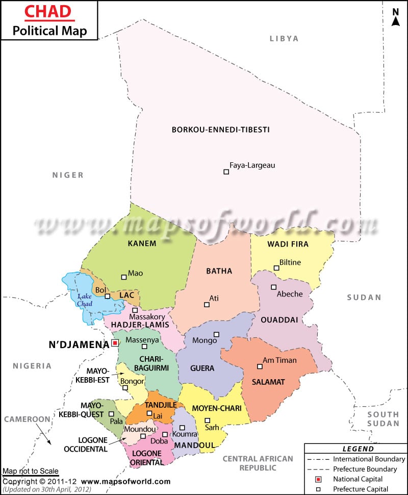
As shown in the Chad Political Map, Chad is bordered on the north by Libya, on the south by the Central African Republic, on the east by the Republic of Sudan, on the southwest by Cameroon, and on the west by Nigeria and Niger.
The national capital of Chad, N’Djamena finds clear representation on the map. It is located in the southwestern part of the country.
Chad’s Political Map features the important cities, provinces and their capitals, and the international borders of the country.
Chad is divided into twenty-two regions that are further divided into sixty-one departments which are subdivided into two-hundred sub-prefectures; these are composed of 446 cantons.
The regions are: Batha, Chari-Baguirmi, Hadjer-Lamis, Wadi Fira, Bahr el Gazel, Borkou, Ennedi, Guera, Kanem, Lac, Logone Occidental, Logone Oriental, Mandoul, Mayo-Kebbi Est, Mayo-Kebbi Ouest, Moyen-Chari, Ouaddai, Salamat, Sila, Tandjile, Tibesti, and N’Djamena.
The major cities as shown in the political map of Chad are:
- Abeche
- Ade
- Am Timan
- Bokoro
- Bongor
- Doba
- Fianga
- Gaoui
- Linia
- Mao
- Pala
- Zouar
- Oum Hadjer
Chad is the Presidential Republic. The President is both head of state and head of government. Mahamat Deby is the current President of the nation.
The position of the Prime Minister is held by Albert Pahimi Padacké
Over eighty percent of the population of the country depends on farming and livestock for their livelihood. Cotton, sorghum, millet, peanuts, rice, potatoes, and tapioca are the major agricultural products. The chief industries of Chad include oil, cotton textiles, meatpacking, beer brewing, soap, cigarettes, and construction materials.
The major trading partners of Chad are the United States, China, Portugal, France, Cameroon, Germany, and Belgium.
Regions of Chad |
| Region | Population: 2009-06-20 | Capital |
|---|---|---|
| Barh el Ghazel | 260,865 | Moussoro |
| Batha | 527,031 | Ati |
| Borkou | 97,251 | Faya-Largeau |
| Chari-Baguirmi | 621,785 | Massenya |
| Ennedi | 173,606 | Fada |
| Guera | 553,795 | Mongo |
| Hadjer-Lamis | 562,957 | Massakory |
| Kanem | 354,603 | Mao |
| Lac | 451,369 | Bol |
| Logone Occidental | 683,293 | Moundou |
| Logone Oriental | 796,453 | Doba |
| Mandoul | 637,086 | Koumra |
| Mayo-Kebbi Est | 769,178 | Bongor |
| Mayo-Kebbi Ouest | 565,087 | Pala |
| Moyen-Chari | 598,284 | Sarh |
| Ouaddai | 731,679 | Abeche |
| Salamat | 308,605 | Am-Timan |
| Sila | 289,776 | Goz Beida |
| Tandjile | 682,817 | Lai |
| Tibesti | 21,970 | Bardai |
| Ville de N’Djamena | 993,492 | N’Djamena |
| Wadi Fira | 494,933 | Biltine |
| Total | 11,175,915 |
Note : – Population : 2009-06-20 census (provisional results).
| Prefecture | Population | Area (km.²) | Capital |
|---|---|---|---|
| Batha | 288,458 | 88,800 | Ati |
| Biltine | 184,807 | 46,850 | Biltine |
| Borkou-Ennedi-Tibesti | 73,185 | 600,350 | Faya-Largeau |
| Chari-Baguirmi | 1,251,906 | 82,910 | N’Djamena |
| Guera | 306,253 | 58,950 | Mongo |
| Kanem | 279,927 | 114,520 | Mao |
| Lac | 252,932 | 22,320 | Bol |
| Logone Occidental | 455,489 | 8,695 | Moundou |
| Logone Oriental | 441,064 | 28,035 | Doba |
| Mayo-Kebbi | 825,158 | 30,105 | Bongor |
| Moyen-Chari | 738,595 | 45,180 | Sarh |
| Ouaddai | 543,900 | 76,240 | Abeche |
| Salamat | 184,403 | 63,000 | Am Timan |
| Tandjile | 453,854 | 18,045 | Lai |
| 14 prefectures |

 Vacations in Chad