- Neighboring Countries - Niger, Nigeria, Togo, Burkina Faso
- Continent And Regions - Africa Map
- Other Benin Maps - Benin Map, Where is Benin, Benin Blank Map, Benin Road Map, Benin Rail Map, Benin Cities Map, Benin Political Map, Benin Physical Map
Download Picture of Blank Benin Flag For Kids to Color
The national flag of Benin has undergone modifications a number of times. It was first adopted on November 16, 1959, but was abandoned in 1975, upon the succession of the Marxist regime.
Later, when the Marxist regime was removed, the flag was re-introduced on August 1, 1990.
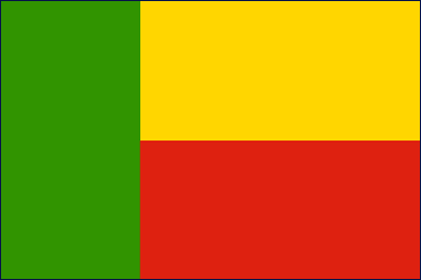
The national flag of Benin consists of three stripes: a green vertical stripe on the left side, a yellow horizontal stripe on top of a red horizontal stripe on the right side of the flag.
The colors used in the flag are traditional Pan-African colors.
The green color of the flag of Benin stands for hope and revival, yellow represents the ongoing preservation of the country’s wealth, and red stands for the strength and courage shown by the nation’s ancestors.
| Official Name: | Republic of Benin |
| Proportion: | 2:3 |
| Adopted on: | August 1, 1990 |
| Location: | West Africa is bordered by Togo, Nigeria, Bight of Benin, Burkina Faso, and Niger |
| Capital City: | Porto-Novo |
| Major Cities: | Cotonou, Djougou, Banikoara, Bohicon, Cove, Dassa-Zoume |
| Area: | 43,484 square miles |
| Population: | 9,325,032 |
| Currency: | West African CFA franc (XOF) |
| Official Language: | French |
| National Anthem: | The Dawn of a New Day |
| National symbol(s): | leopard |
| National colors: | green, yellow, red |
| National anthem: | The dawn of a new day |
| Name: | “L’Aube Nouvelle” (The Dawn of a New Day) |
| Lyrics/Music: | Gilbert Jean DAGNON |


 Benin Science and Technology