- Neighboring Countries - St Vincent and the Grenadines, St Lucia, Grenada, Dominica, Antigua
- Continent And Regions - North America Map, Americas Map
- Other Barbados Maps - Barbados Map, Where is Barbados, Barbados Blank Map, Barbados Road Map, Barbados River Map, Barbados Cities Map, Barbados Flag
Barbados is the most easterly island country in the Lesser Antilles of the West Indies in the Caribbean islands of America. The government is situated in the Atlantic Ocean. Barbados lies east of the countries of Saint Lucia and Saint Vincent and the Grenadines, northeast of Trinidad and Tobago, southeast of Martinique, and west of Windward Islands.
Barbados Physical Features
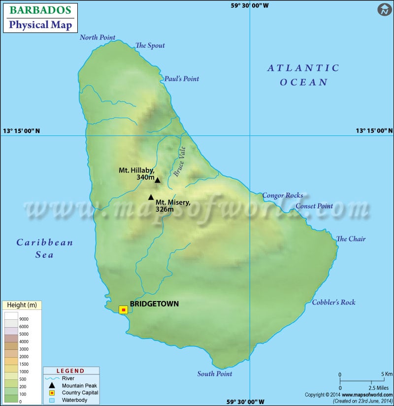
The island nation is east-west 23 km (14 mi) wide and 34 kilometers (21 mi) long, covering a total land area of 432 km2 (167 sq mi). It has a coastline of 97 km (60 mi) length. Barbados’s largest city and capital are Bridgetown, marked on the map. A map legend at the bottom gives all the signs, characters, graphics, and symbols used throughout the map. The map can be used for school work, presentations, and other purposes. The topography of Barbados is mainly lowlands or gently sloping terraced plains.
These plains are separated by interior rolling Hills that parallel the coast. 85% of the country’s surface consists of Coralline limestone about 30 m thick. Coral reefs surround the island country. The significant relief features of Barbados are listed below:
Mount Hillaby and Christ Church Ridge
Mount Hillaby is the highest point of Barbados at 340 meters (1102 feet) above sea level. Mount Hillaby is located in the parish of Saint Andrew, overlooking the area of the Scotland District to the east and north. The Christ Church Ridge is situated in the Farther south with elevations ranging from 60 to 90 meters. It is formed between St Georges Valley and the sea.
Scotland District
Scotland District is the rugged upland in the parish of St. Andrew on the Atlantic side of Barbados. The land declines east from Mount Hillaby to Scotland District. Scotland District is based at the top of the submarine mountain range. The region is composed of clay stones, volcanic ash and chalk, and geologically old sediments prone to erosion. The area has many outcroppings of Coral rocks, mainly on the beaches.
Pico Teneriffe
This Rocky Cape is the coral reef in the shape of a pinnacle, another significant feature of Barbados. Pico Teneriffe lies on the North-East coast of Barbados, between the parishes of Saint Andrew and Saint Peter. The Rocky Cape reaches 100 meters in height. According to the locals, it is named after the island of Tenerife in Spain, which is the first land east of Barbados.
Drainage in Barbados
There are no significant rivers or lake systems except for a few streams, ponds, and springs. Water is derived from the underground network of reservoirs and caves. The water is majorly rainwater that seeps into the ground draining into underground streams.

 Barbados Facts