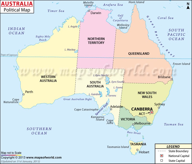
- Australia States - New South Wales, Northern Territory, Queensland, South Australia, Tasmania, Victoria, Western Australia
- Australia Cities - Adelaide, Brisbane, Broom, Cairns, Darwin, Gold Coast, Hobart, Canberra, Newcastle, Perth
- Neighboring Countries - Papua New Guinea, Vanuatu, Newzealand, Solomon Islands, Fiji
- Continent And Regions - Oceania Map
- Other Australia Maps - Australia Map, Where is Australia, Australia Blank Map, Australia Road Map, Australia Rail Map, Australia Physical Map, Australia Flag, How Many Time Zones are in Australia
Australia is divided into six states and three internal territories, as well as other various external territories off the mainland, which includes six island territories and the Australian Antarctic Territory.
Australia’s six states are South Australia, New South Wales, Victoria, Western Australia, Queensland, and Tasmania, which is located on an island just off the southern coast of Australia. These six are the federated states of Australia, and are under direct rule of the Queen.
The most populous of Australia’s states is New South Wales, with a population of over seven million people. New South Wales is situated on the southeastern coast of Australia, with its capital and largest city in Sydney.
Western Australia, though its population numbers around 2.4 million, is the largest of Australia’s states by area, covering 2,645,615 square kilometers (1,021,478 square miles), and the western third of the country.
Also located on mainland Australia are the Australian Capital Territory and the Northern Territory, which are both self-governing. The Australian Capital Territory is the seat of government of Australia, which is centered in Canberra.
The external Australian territories include Norfolk Island, Christmas Island, and Cocos (Keeling) Islands.
Australia States/Territories and their Capitals |
|---|
| States/Territories | Population | Area(km.²) | Area(mi.²) | Capital |
|---|---|---|---|---|
| Australian Capital Territory | 323,665 | 2,365 | 913 | Canberra |
| Jervis Bay Territory | 369 | 67 | 26 | Canberra |
| New South Wales | 6,549,177 | 801,425 | 309,432 | Sydney |
| Northern Territory | 192,898 | 1,356,170 | 523,620 | Darwin |
| Queensland | 3,904,532 | 1,736,587 | 670,500 | Brisbane |
| South Australia | 1,514,337 | 984,377 | 380,070 | Adelaide |
| Tasmania | 476,481 | 68,127 | 26,304 | Hobart |
| Victoria | 4,932,422 | 227,619 | 87,884 | Melbourne |
| Western Australia | 1,959,088 | 2,527,621 | 975,920 | Perth |
| Ashmore and Cartier Islands | 0 | 5 | 2 | Darwin |
| Coral Sea Islands Territory | 0 | 3 | 1 | Kingston |
 Wall Maps