- Neighboring Countries - Namibia, Zambia, Democratic Republic of the Congo, Botswana, Republic of the Congo
- Continent And Regions - Africa Map
- Other Angola Maps - Angola Map, Where is Angola, Angola Blank Map, Angola Road Map, Angola Rail Map, Angola River Map, Angola Cities Map, Angola Physical Map, Angola Flag
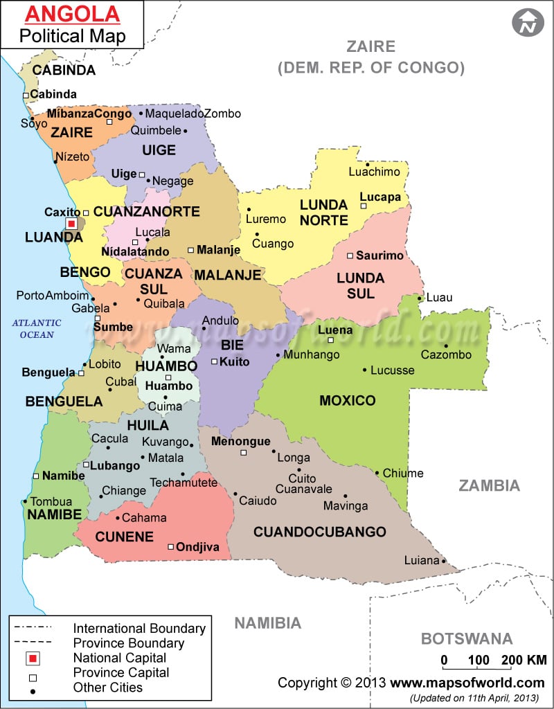
In the map of Angola the international boundaries of the country are marked. South Atlantic Ocean, Nambia, Zambia and the Democratic Republic of the Congo border Angola. The capital of the country is Luanda.
The Angola Political map also points out the provinces along with their capitals. The country has 18 provinces.
Angola is situated in the south-central part of Africa. It is located around 12°30’S Latitude and 18°30’E longitude. Angola is spread over a total area of 1,246,700 Square Kilometers. The 18 provinces, in which the country has been divided for administration, are Bie, Namibe, Uige, Moxico, Zaire, Cunene, Huambo, Huila, Bengo, Lunda Sul, Malanje, Cabinda, Cuando, Cubango, Cuanza Norte, Cuanza Sul, Luanda, Benguela and Lunda Norte.
The province capitals, which are indicated on the Angola map are mentioned below:
|
|
The major cities are pointed out with black dots on the map of Angola. The cities are Lucala, Lucusse, Cazombo, Munhango, Cubal, Lobito, Quibala, Luremo, Gabela, Cuango, Maquelado, Luachimo, Luremo, Negarge and Soyo.
Capital of Angola
Luanda is the capital of the country. It is also the largest city in Angola. The city is located at 8°50’18”S Latitude and 13°14’4”E Longitudes. It is situated at an altitude of 22 feet above sea level on the coast of Angola by the Atlantic Ocean. Feitaria, Salinas da Samba, Maianga, Muceques, and Golfe are the cities located near the city. In the printable map of Angola, the position of the capital can be easily identified as it is marked in red color. Luanda is home to the Quarto de Fevereiro Airport.
| Province | Pop-1960 | Pop-1950 | Area(km.&sup²) |
|---|---|---|---|
| Benguela | 487,871 | 328,765 | 38,960 |
| Bie-Cuando Cubango | 567,253 | 475,956 | 263,730 |
| Cabinda | 58,453 | 50,506 | 7,270 |
| Congo | 503,178 | 400,153 | 92,570 |
| Cuanza-Norte | 263,101 | 216,463 | 31,210 |
| Cuanza-Sul | 405,012 | 296,610 | 44,850 |
| Huambo | 598,545 | 567,062 | 30,600 |
| Huila | 592,451 | 503,605 | 188,830 |
| Luanda | 347,173 | 281,791 | 34,610 |
| Lunda | 247,449 | 266,087 | 166,880 |
| Malanje | 451,719 | 461,653 | 114,060 |
| Mocamedes | 43,393 | 44,940 | 34,340 |
| Moxico | 267,079 | 251,675 | 198,790 |

 Angola Facts