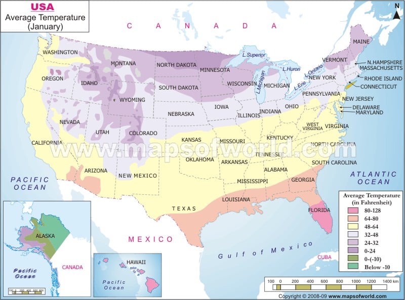
The United States of America is a large-sized country having different temperature zones.
Western and the Southern parts of the United States are usually warmer compared to the Eastern and Northern parts. The northern half and the North Eastern parts of the country are extremely cold during the winters, whereas the rest have a tolerable amount of winter.
Does the US temperature January map denote eight different temperature zones of America from below -10? F to 128? F. This US temperature January map indicates that Alaska is the most fantastic area in the entire country, where the average least cold state of the country in January. January is one of the driest months in America, with an average precipitation of 2.05 inches. 328? F is the usual average temperature in January.
NEIGHBOUR COUNTRIES:
SEAS, OCEANS, RIVERS, BAYS:
Pacific Ocean, Gulf of Mexico, Atlantic Ocean.
Average January temperatures for US cities |
|---|
| High °F | Low °F | City | High °C | Low °C |
|---|---|---|---|---|
| 52 | 34 | Atlanta, Georgia | 11 | 1 |
| 62 | 42 | Austin, Texas | 16 | 5 |
| 41 | 24 | Baltimore, Maryland | 5 | -4 |
| 54 | 34 | Birmingham, Alabama | 12 | 1 |
| 36 | 22 | Boston, Massachusetts | 2 | -5 |
| 31 | 19 | Buffalo, New York | 0 | -8 |
| 51 | 30 | Charlotte, North Carolina | 10 | -1 |
| 31 | 17 | Chicago, Illinois | -1 | -9 |
| 40 | 22 | Cincinnati, Ohio | 5 | -5 |
| 34 | 22 | Cleveland, Ohio | 1 | -6 |
| 37 | 23 | Columbus, Ohio | 3 | -5 |
| 57 | 37 | Dallas, Texas | 14 | 3 |
| 45 | 17 | Denver, Colorado | 7 | -8 |
| 32 | 19 | Detroit, Michigan | 0 | -7 |
| 35 | 18 | Hartford, Connecticut | 1 | -8 |
| 63 | 43 | Houston, Texas | 17 | 6 |
| 36 | 21 | Indianapolis, Indiana | 2 | -6 |
| 65 | 41 | Jacksonville, Florida | 18 | 5 |
| 40 | 22 | Kansas City, Missouri | 4 | -5 |
| 58 | 39 | Las Vegas, Nevada | 14 | 4 |
| 68 | 48 | Los Angeles, California | 20 | 9 |
| 43 | 27 | Louisville, Kentucky | 6 | -3 |
| 50 | 33 | Memphis, Tennessee | 10 | 0 |
| 76 | 60 | Miami, Florida | 25 | 16 |
| 29 | 16 | Milwaukee, Wisconsin | -2 | -9 |
| 24 | 8 | Minneapolis, Minnesota | -5 | -14 |
| 47 | 28 | Nashville, Tennessee | 8 | -2 |
| 62 | 45 | New Orleans, Louisiana | 17 | 7 |
| 38 | 27 | New York, New York | 4 | -3 |
| 50 | 29 | Oklahoma City, Oklahoma | 10 | -2 |
| 71 | 49 | Orlando, Florida | 22 | 10 |
| 40 | 26 | Philadelphia, Pennsylvania | 5 | -4 |
| 69 | 46 | Phoenix, Arizona | 20 | 8 |
| 36 | 21 | Pittsburgh, Pennsylvania | 2 | -6 |
| 47 | 36 | Portland, Oregon | 8 | 2 |
| 37 | 21 | Providence, Rhode Island | 3 | -6 |
| 51 | 30 | Raleigh, North Carolina | 11 | -1 |
| 47 | 28 | Richmond, Virginia | 9 | -2 |
| 69 | 43 | Riverside, California | 21 | 6 |
| 32 | 18 | Rochester, New York | 0 | -8 |
| 54 | 39 | Sacramento, California | 12 | 4 |
| 37 | 22 | Salt Lake City, Utah | 3 | -6 |
| 63 | 41 | San Antonio, Texas | 17 | 5 |
| 65 | 49 | San Diego, California | 18 | 9 |
| 57 | 46 | San Francisco, California | 14 | 8 |
| 58 | 42 | San Jose, California | 15 | 6 |
| 49 | 37 | Seattle, Washington | 9 | 3 |
| 40 | 24 | St. Louis, Missouri | 4 | -5 |
| 70 | 52 | Tampa, Florida | 21 | 11 |
| 48 | 33 | Virginia Beach, Virginia | 9 | 0 |
| 43 | 29 | Washington, DC | 6 | -2 |
