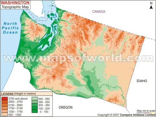
Mount Olympus with a height of 7965 ft is the highest elevation point of the Olympic Mountains. Cascade Range is another important feature of the topography of Washington. The Western Corridor, which falls between the Cascade Range and Pacific Coast, houses the most significant cities of the state. While most of the Washington state comprises rocky regions, the south-central zone is counted as a flat area. The lakes and rivers also occupy a major portion of the Washington topography. While the 123 sq miles of artificial Franklin D. Roosevelt Lake is considered as the largest one in Washington, Columbia river is the longest waterway of the state. The Grand Coulee Dam, known as one of the largest with respect to its size, is constructed over the upper parts of Columbia river. Snake River is another prominent natural stream of Washington which drains to Columbia river by flowing towards the western direction. The Washington state map provides a vivid idea about the physiographic traits of the place.
Washington Topographic Map
The topography of Washington mainly includes mountainous regions. The Willapa Hills and the Olympic Mountains are the two integral parts of Washington's topography. The Washington Topographic Map shows the various physiographic regions of the state.
