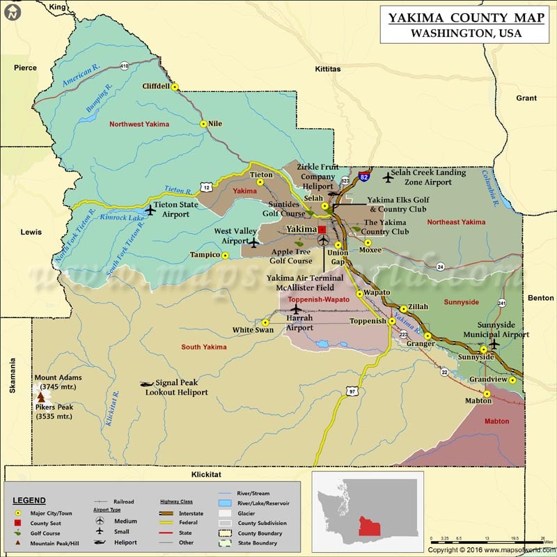
Check this Washington County Map to locate all the state’s counties in Washington Map.
Yakima County is located in southern Washington state. It is named after the Yakama tribe of Native Americans. Yakima is the county seat and its largest city. Carved out of Ferguson County in 1865, the county covers an area of 4,311 square miles, which is larger than the area of Delaware and Rhode Island states combined. Spanning nearly 36% of the country’s area, Yakama Indian Reservation is the 15th largest reservation in the US. Toppenish is the most populous settlement in this reservation.
The Yakima River Valley is known for apple, wine, and hop production. The Yakima Valley American Viticultural Area produces more than 40% of the state’s wine. The Yakima Valley Museum chronicles the region’s natural and cultural history. The Central Washington State Fair is held annually in Yakima. With an elevation of 3,743 meters, Mount Adams is the highest point in Yakima County. Interstate 82, US 12, and US 97 are primary highways in the county. Fort Simcoe Historical State Park, White Pass Ski Area, Franklin Park, and Teapot Dome Service Station are popular attractions in the region.
Places to Visit in Yakima |
| Place | Location | Contact No. |
|---|---|---|
| Yakima Area Arboretum & Botanical Garden | 1401 Arboretum Dr, Yakima, WA 98901 | 5092487337 |
| Yakima Valley Museum | 2105 Tieton Drive, Yakima, WA | +1 509-248-0747 |
| Bale Breaker Brewing Company | 1801 Birchfield Rd, Yakima, WA 98901-9577 | +1 509-424-4000 |
| Cowiche Canyon Trail | Cowiche Canyon Road, Yakima, WA | NA |
| Yakima Convention Center | 10 N 8th St, Yakima, WA 98901 | +1 509-575-6062 |
| Gilbert Cellars | 5 N Front St, Yakima, WA 98901 | +1 509-249-9049 |
| Fort Simcoe State Park | Yakima, WA | +1 509-874-2372 |
| Yakima Valley Visitors Center | 101 N Fair Ave, Yakima, WA 98901-4514 | +1 509-573-3388 |
| State Fair Park & Yakima Valley SunDome | 1301 South Fair Avenue, Yakima, WA 98901 | +1 509-248-7160 |
| Yakima Farmers Market | S. 3rd Street & East Yakima Ave, Yakima, WA98908 | +1 509-457-5765 |
| Yakima Sportsman State Park | 904 University Pkwy, Yakima, WA 98901-9523 | +1 509-575-2774 |
| The Tasting Room | 250 Ehler Road, Yakima, WA 98908 | +1 509-966-0686 |
| Majestic Theatre | 1919 S 14th St, Yakima, WA 98903-1282 | +1 509-248-0242 |
| Hop Nation Brewery | 31 N 1st Ave, Yakima, WA 98902-2663 | +1 509-367-6552 |
| Kana Winery | 10 S. 2nd Street, Yakima, WA 98901 | +1 509-453-6611 |
Facts about Yakima county in Washington |
|
|---|---|
| County Name | Yakima county |
| Population | 2,47,687 |
| Founded | 21 January 1865 |
| Area | 4,311 sq mi (11,165 sq km) |
| Land Area | 4,296 sq mi (11,127 sq km) |
| Water Area | 16 sq mi (41 sq km), 0.4% |
| Largest City | Yakima |
| Cities | Yakima, Union Gap, Zillah, Cowiche, West Valley, Buena, Granger, Moxee, Wapato, Selah, Sunnyside, Naches, Mabton, Harrah, Tampico, Parker, Outlook, Tieton, Grandview, Toppenish, Donald |
| County Seat | Yakima |
| Timezone | Pacific: UTC-8/-7 |
 Wall Maps