US States Map > Map of Washington > Washington Counties > King County Map, Washington

King County Map, Washington

by Vishul Malik

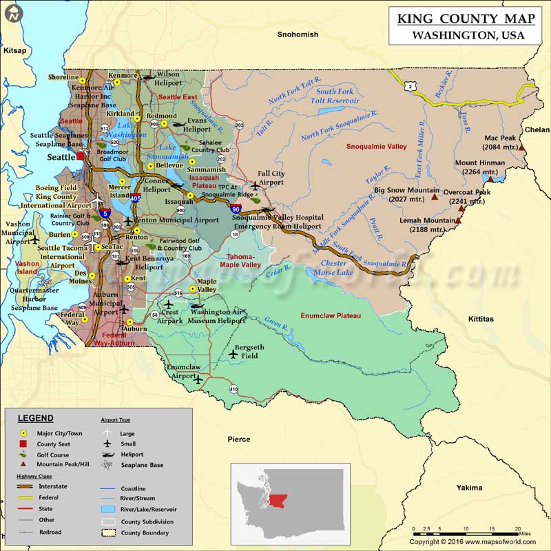
Check this Washington County Map to locate all the state’s counties in Washington Map. King County is located in the Puget Sound region of Washington state. With over two million inhabitants, it is…


King County Map, Washington

Check this Washington County Map to locate all the state’s counties in Washington Map.

King County is located in the Puget Sound region of Washington state. With over two million inhabitants, it is the most populous county in the state and the 13th most populous in the country. Seattle which is the largest city in Washington is the county seat. Established on December 22, 1852, the county covers a total area of 2,307 square miles, twice the area of Rhode Island. Mount Daniel, with an elevation of 2,426 meters, is the highest point in King County.

More than 60 percent of the county residents live in the city’s suburbs. Snoqualmie Valley, a farming and timber-producing region, covers the eastern portion of the county. Snoqualmie Lake, Lake Washington, Big Heart Lake, and Lake Union are major bodies of water in the county.

Sea-Tac Airport (SEA) is the primary airport for county residents. Interstate 5, I-90, SR 18, SR 99, and U.S. Route 2 are major roads in the county. Seattle is famous for a number of tourist attractions including Space Needle, Pike Place Market, Museum of Flight, Lake Washington, Woodland Park Zoo, and Golden Gardens Park. One of Washington’s most popular scenic attractions, the 82-m-tall Snoqualmie Falls attracts over a million visitors every year.

More Maps of King County

Facts about King county in Washington

County Name King County
Population 20,79,967
Founded 22 December 1852
Area 2,307 sq mi (5,975 sq km)
Land Area 2,115 sq mi (5,478 sq km)
Water Area 191 sq mi (495 sq km), 8.3%
Largest City Seattle
Cities Seattle, Kirkland, Shoreline, Sammamish, SeaTac, Covington, Duvall, Clyde Hill, Beaux Arts Village, West Lake Sammamish, Lester, Yarrow Point, Skykomish, Newcastle, Carnation, Black Diamond, Normandy Park, Hunts Point, Klahanie, Lea Hill, Algona, Medina,
County Seat Seattle
Timezone Pacific: UTC-8/-7

Related Maps

Looks like your ad blocker is on.

×

We rely on ads to keep creating quality content for you to enjoy for free.

Please support our site by disabling your ad blocker.

Continue without supporting us

Choose your Ad Blocker

  • Adblock Plus
  • Adblock
  • Adguard
  • Ad Remover
  • Brave
  • Ghostery
  • uBlock Origin
  • uBlock
  • UltraBlock
  • Other
  1. In the extension bar, click the AdBlock Plus icon
  2. Click the large blue toggle for this website
  3. Click refresh
  1. In the extension bar, click the AdBlock icon
  2. Under "Pause on this site" click "Always"
  1. In the extension bar, click on the Adguard icon
  2. Click on the large green toggle for this website
  1. In the extension bar, click on the Ad Remover icon
  2. Click "Disable on This Website"
  1. In the extension bar, click on the orange lion icon
  2. Click the toggle on the top right, shifting from "Up" to "Down"
  1. In the extension bar, click on the Ghostery icon
  2. Click the "Anti-Tracking" shield so it says "Off"
  3. Click the "Ad-Blocking" stop sign so it says "Off"
  4. Refresh the page
  1. In the extension bar, click on the uBlock Origin icon
  2. Click on the big, blue power button
  3. Refresh the page
  1. In the extension bar, click on the uBlock icon
  2. Click on the big, blue power button
  3. Refresh the page
  1. In the extension bar, click on the UltraBlock icon
  2. Check the "Disable UltraBlock" checkbox
  3. Marque la casilla de verificación "Desactivar UltraBlock"
  1. Please disable your Ad Blocker

If the prompt is still appearing, please disable any tools or services you are using that block internet ads (e.g. DNS Servers).

Logo