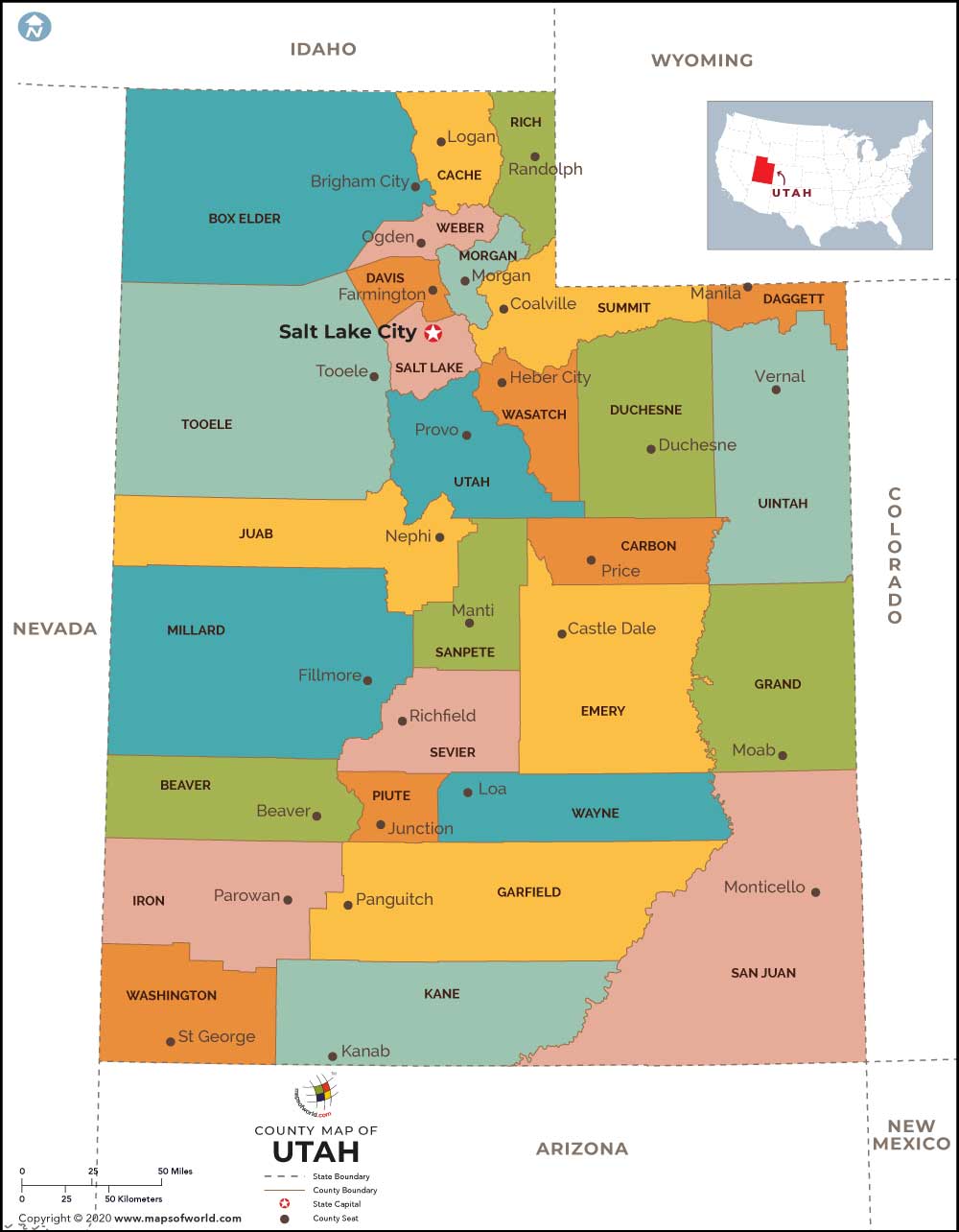
Counties in Utah State
Utah has a total of 29 counties as the administrative divisions. All the 29 counties of Utah are governed by separate county seats. A range of local-level governmental activities are carried out by these counties of the state of Utah. The Utah county Map points out the geographical position of the counties.
List of Counties in Utah |
|---|
| County Name | Population (2016) |
Area (sq. mi.) |
|---|---|---|
| Beaver County Map | 6,463 | 2589.95 |
| Box Elder County Map | 53,139 | 5723.34 |
| Cache County Map | 122,753 | 1164.52 |
| Carbon County Map | 20,399 | 1478.46 |
| Daggett County Map | 1,095 | 698.36 |
| Davis County Map | 342,281 | 304.48 |
| Duchesne County Map | 20,337 | 3238.05 |
| Emery County Map | 10,216 | 4451.85 |
| Garfield County Map | 4,986 | 5174.22 |
| Grand County Map | 9,579 | 3681.56 |
| Iron County Map | 49,937 | 3297.98 |
| Juab County Map | 11,010 | 3391.74 |
| Kane County Map | 7,334 | 3991.96 |
| Millard County Map | 12,694 | 6589.13 |
| Morgan County Map | 11,437 | 609.13 |
| Piute County Map | 1,466 | 757.81 |
| Rich County Map | 2,319 | 1028.53 |
| Salt Lake County Map | 1,121,354 | 737.38 |
| San Juan County Map | 16,895 | 7820.18 |
| Sanpete County Map | 29,409 | 1588.11 |
| Sevier County Map | 21,267 | 1910.25 |
| Summit County Map | 40,307 | 1871.05 |
| Tooele County Map | 64,833 | 6930.35 |
| Uintah County Map | 36,373 | 4477.07 |
| Utah County Map | 592,299 | 1998.33 |
| Wasatch County Map | 30,528 | 1177.39 |
| Washington County Map | 160,245 | 2426.62 |
| Wayne County Map | 2,702 | 2460.32 |
| Weber County Map | 247,560 | 575.54 |
 Wall Maps
