US States Map > Texas Map > Texas County Maps > Presidio County Map, Texas

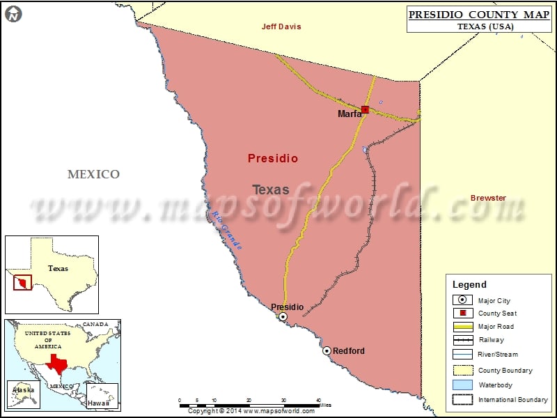
Presidio County Map, Texas

by Vishul Malik

Check this Texas County Map to locate all the state’s counties in Texas Map. Mountain Peaks in Presidio County Mountain Peak/Hill Elevation [Meter] Agua Adentro Mountain 1501 Aguja 1827 Alazan Hills 1475 Antelope…


Presidio County Map, Texas

Check this Texas County Map to locate all the state’s counties in Texas Map.

Mountain Peaks in Presidio County

Mountain Peak/Hill Elevation [Meter]
Agua Adentro Mountain 1501
Aguja 1827
Alazan Hills 1475
Antelope Mesa 1466
Black Hills 1027
Black Hills 1569
Black Peaks 1650
Bofecillos Peak 1516
Capote Peak 1890
Cathedral Peak 1434
Cerro Boludo 1443
Cerro Chino 1362
Cerro de la Cruz 1357
Cerro de las Burras 1321
Cerro Orona 1912
Cerro Pardo 1635
Cerro Tren 1298
Chalk Mountain 1214
Chinati Peak 2354
Church Mountain 1207
Cienega Mountains 1384
Cleveland Peak 1977
Contrabando Mountain 982
Crenshaw Mountain 1789
El Macho 1759
Frenchman Hills 1451
Fresno Peak 1544
Gemelo Mesa 1536
Gettysburg Peak 1481
Hat Mountain 1596
Horseshoe Mesa 1539
Housetop Mountain 1620
La Mesa 1649
La Mota Mountain 1529
La Viuda 1229
Loma Blanca 1165
Needle Peak 1376
Needle Peak 1262
Orphan Hill 1582
Oso Mountain 1546
Panther Mountain 1501
Post Mountain 1388
Quinn Mesa 1283
Rancheria Hills 1471
Red Hill 1217
Red Hill 1292
Rincon Mountain 1343
San Jacinto Mountain 1493
Santana Mesa 1175
Sierra Parda 2190
Soldier Mesa 1358
Solitario Peak 1418
Tascotal Mesa 1549
The Dike 1145
The Solitario 1408
Wax Factory Laccolith 953

Airports in Presidio County

Airport Name
Alta Vista Ranch Airport
Big Bend Ranch State Park Airport
Candelaria Airport
Cibolo Creek Ranch Airport
Hot Springs Airport
Marfa Municipal Airport
Presidio Lely International Airport
Rawls Ranch Airport

Cities in Presidio County

City Population Latitude Longitude
Marfa city 1981 30.310726 -104.025433
Presidio city 4426 29.56036 -104.365322
Redford 90 29.434162 -104.182412

Golf Courses in Presidio County

Name of Golf Course Latitude Longitude
Marfa Municipal Golf Course-Marfa 30.318671 -103.999351

Related Maps

Looks like your ad blocker is on.

×

We rely on ads to keep creating quality content for you to enjoy for free.

Please support our site by disabling your ad blocker.

Continue without supporting us

Choose your Ad Blocker

  • Adblock Plus
  • Adblock
  • Adguard
  • Ad Remover
  • Brave
  • Ghostery
  • uBlock Origin
  • uBlock
  • UltraBlock
  • Other
  1. In the extension bar, click the AdBlock Plus icon
  2. Click the large blue toggle for this website
  3. Click refresh
  1. In the extension bar, click the AdBlock icon
  2. Under "Pause on this site" click "Always"
  1. In the extension bar, click on the Adguard icon
  2. Click on the large green toggle for this website
  1. In the extension bar, click on the Ad Remover icon
  2. Click "Disable on This Website"
  1. In the extension bar, click on the orange lion icon
  2. Click the toggle on the top right, shifting from "Up" to "Down"
  1. In the extension bar, click on the Ghostery icon
  2. Click the "Anti-Tracking" shield so it says "Off"
  3. Click the "Ad-Blocking" stop sign so it says "Off"
  4. Refresh the page
  1. In the extension bar, click on the uBlock Origin icon
  2. Click on the big, blue power button
  3. Refresh the page
  1. In the extension bar, click on the uBlock icon
  2. Click on the big, blue power button
  3. Refresh the page
  1. In the extension bar, click on the UltraBlock icon
  2. Check the "Disable UltraBlock" checkbox
  3. Marque la casilla de verificación "Desactivar UltraBlock"
  1. Please disable your Ad Blocker

If the prompt is still appearing, please disable any tools or services you are using that block internet ads (e.g. DNS Servers).

Logo