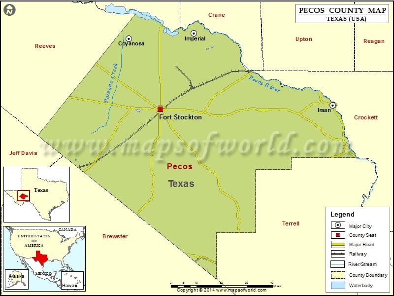
Check this Texas County Map to locate all the state’s counties in Texas Map.
Mountain Peaks in Pecos County
| Mountain Peak/Hill | Elevation [Meter] |
|---|---|
| Big Baldy Peak | 878 |
| Big Mesa | 898 |
| Big Mesa | 960 |
| Boat Hills | 1314 |
| Cap Rock Butte | 1290 |
| Cave Mesa | 1336 |
| Clark Butte | 1460 |
| Darrels Peak | 911 |
| Dimple Hills | 1447 |
| East Mesa | 953 |
| Fivemile Hill | 972 |
| Fivemile Mesa | 1024 |
| Flat Top | 902 |
| Girvin Butte | 844 |
| Guayule Mountain | 957 |
| Hayter Hill | 1005 |
| Hog Peak | 918 |
| Indian Mesa | 947 |
| Little Mesa | 891 |
| McKenzie Mesa | 1010 |
| North Mountain | 1295 |
| Panther Bluff | 892 |
| Panther Mesa | 1280 |
| Panther Peak | 1275 |
| Pikes Peak | 1154 |
| Pine Mesa | 1411 |
| Round Mountain | 1091 |
| Round Mountain | 919 |
| Saddle Butte | 920 |
| Sevenmile Mesa | 887 |
| Sherbino Mesa | 990 |
| Sierra Madera | 1370 |
| Skyscraper Peak | 911 |
| The Needle Point | 908 |
| Triple Butte | 1107 |
| Tucker Hill | 990 |
| Twelvemile Mesa | 1139 |
| Twomile Hill | 961 |
Airports in Pecos County
| Airport Name |
|---|
| Allison Ranch Airport |
| Canon Ranch Airport |
| Faith Cattle Company, Longfellow Ranch Airport |
| Fort Stockton Pecos County Airport |
| Iraan Municipal Airport |
| Smokey Mtn Ranch Airport |
Cities in Pecos County
| City | Population | Latitude | Longitude |
|---|---|---|---|
| Coyanosa | 163 | 31.240978 | -103.064828 |
| Fort Stockton city | 8283 | 30.892673 | -102.885707 |
| Imperial | 278 | 31.266845 | -102.69465 |
| Iraan city | 1229 | 30.912903 | -101.900074 |
Golf Courses in Pecos County
| Name of Golf Course | Latitude | Longitude |
|---|---|---|
| Desert Pnes Golf Course-Fort Stockton | 30.884353 | -102.890957 |
| Iraan Golf Club-Iraan | 30.69051 | -101.823439 |
 Wall Maps