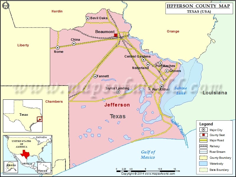
Check this Texas County Map to locate all the state’s counties in Texas Map.
Mountain Peaks in Jefferson County
| Mountain Peak/Hill | Elevation [Meter] |
|---|---|
| Big Hill | 10 |
| Spindletop Hill | 4 |
More Maps of Jefferson County
- Jefferson County Map, Wisconsin
- Jefferson County Map, Nebraska
- Jefferson County Map, Alabama
- Jefferson County Map, Florida
- Jefferson County Map, New York
- Jefferson County Map, Tennessee
- Jefferson County Map, Washington
- Jefferson County Map, Georgia
Airports in Jefferson County
| Airport Name |
|---|
| Air Logistics Sabine Heliport |
| Arco High Island Heliport |
| Arco Sabine Heliport |
| Baptist Hospital of Se Texas Heliport |
| Beaumont Municipal Airport |
| Bogan & Fontenot Airport |
| Broussard Farm Airport |
| Era Helicopters Sabine Base Heliport |
| Evergreen Helicopters Heliport |
| Farm Air Service Airport |
| Freedom Springs Ranch Airport |
| Griffith Ranch Airport |
| Hyco Heliport Nr 3 Heliport |
| Kbmt-Tv Heliport |
| Kelley Crop Service Airport |
| Medical Center Of Southeast Texas Heliport |
| Mfs Sabine Pass Heliport |
| P P H Heliport |
| Patco Heliport |
| Sheraton Spindletop Hotel Heliport |
| Sonny Broussard Landing Strip |
| Southeast Texas Regional Airport |
| St Luke’s Episcopal Hospital Heliport |
| St Mary Hospital of Port Arthur Heliport |
| Stonecipher Airport |
| Texaco Chemical Company-East Heliport |
| Texas Menhaden Strip |
| Veterans Affairs Medical Center Heliport |
| Wilber Farms Airport |
Cities in Jefferson County
| City | Population | Latitude | Longitude |
|---|---|---|---|
| Beaumont city | 118296 | 30.084417 | -94.144107 |
| Bevil Oaks city | 1274 | 30.151715 | -94.271119 |
| Central Gardens | 4347 | 29.989294 | -94.021661 |
| China city | 1160 | 30.052469 | -94.333136 |
| Fannett | 2252 | 29.924942 | -94.238953 |
| Groves city | 16144 | 29.945659 | -93.91641 |
| Nederland city | 17547 | 29.971015 | -94.000991 |
| Nome city | 588 | 30.036484 | -94.406105 |
| Port Neches city | 13040 | 29.976479 | -93.945919 |
| Taylor Landing city | 228 | 29.86418 | -94.13484 |
Golf Courses in Jefferson County
| Name of Golf Course | Latitude | Longitude |
|---|---|---|
| Babe Zaharias Golf Course-Port Arthur | 29.93939 | -93.980185 |
| Bayou Din Golf Club-Beaumont | 29.963928 | -94.164686 |
| Beaumont Country Club-Beaumont | 30.131375 | -94.098412 |
| Belle Oaks Golf Club-Beaumont | 29.869824 | -94.136363 |
| Brentwood Country Club-Beaumont | 30.030556 | -94.189153 |
| Henry Homberg Golf Course-Beaumont | 30.030394 | -94.14981 |
| Iron Oaks Golf Club-Beaumont | 30.02627 | -94.198488 |
| The Palms Golf Course At Pleasure Island-Port Arthur | 29.870768 | -93.925455 |
| The Patch Golf Club-Groves | 29.947296 | -93.929046 |
National Parks in Jefferson County
| Name of Park | Latitude | Longitude |
|---|---|---|
| Big Thicket N PRES | 30.344357 | -94.267845 |
 Wall Maps