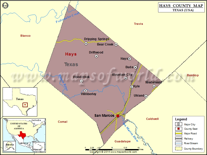
Check this Texas County Map to locate all the state’s counties in Texas Map.
Mountain Peaks in Hays County
| Mountain Peak/Hill | Elevation [Meter] |
|---|---|
| Barton Hill | 233 |
| Carpenter Hills | 269 |
| Coal Kiln Hill | 279 |
| Eagle Mountain | 302 |
| Friday Mountain | 323 |
| Gainor Mountain | 429 |
| Jack Mountain | 451 |
| Joe Wimberley Mountain | 317 |
| Little Twin Sister Peaks | 356 |
| Lone Man Mountain | 416 |
| Lone Woman Mountain | 423 |
| Moon Mountain | 372 |
| Mount Sharp | 463 |
| Old Baldy | 357 |
| Peach Mountain | 429 |
| Roundtree Mountain | 440 |
| Signal Hill | 353 |
| Tower Hill | 402 |
| Trunk Hill | 265 |
Airports in Hays County
| Airport Name |
|---|
| Alexander Ranch Airport |
| Bleakley Ranch Airport |
| Chaney San Francisco Ranch Airport |
| Garnett Ranch Airport |
| Jim Roach Field |
| Keyes Ranch Airport |
| Ohho Airport |
| Restoration Ranch Airport |
| Rutherford Ranch Airport |
| Seton Medical Center Hays Heliport |
| White Wings Airport |
| Wyatt Airport |
Cities in Hays County
| City | Population | Latitude | Longitude |
|---|---|---|---|
| Bear Creek village | 382 | 30.182557 | -97.939981 |
| Buda city | 7295 | 30.085562 | -97.844373 |
| Driftwood | 144 | 30.133072 | -98.037293 |
| Dripping Springs city | 1788 | 30.187319 | -98.08759 |
| Hays city | 217 | 30.121515 | -97.872394 |
| Kyle city | 28016 | 30.001512 | -97.862948 |
| Mountain City city | 648 | 30.03919 | -97.891508 |
| Niederwald city | 565 | 30.003878 | -97.752982 |
| San Marcos city | 44894 | 29.876664 | -97.931004 |
| Uhland city | 1014 | 29.961528 | -97.792444 |
| Wimberley city | 2626 | 29.984806 | -98.090552 |
| Woodcreek city | 1457 | 30.026732 | -98.111329 |
Golf Courses in Hays County
| Name of Golf Course | Latitude | Longitude |
|---|---|---|
| Plum Creek Golf Course-Kyle | 30.028024 | -97.87912 |
| Quicksand At Woodcreek Golf Club-Wimberley | 30.022412 | -98.11343 |
| Texas State University San Marcos-San Marcos | 29.893962 | -97.924962 |
 Wall Maps