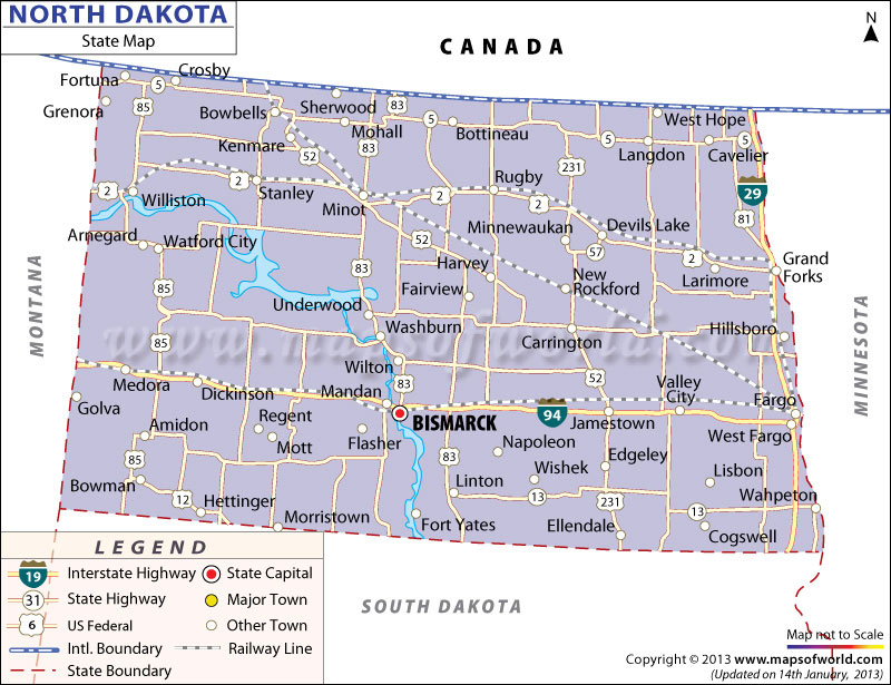
About North Dakota Map:
The above map of North Dakota shows that the state has Montana, Minnesota, and South Dakota as its neighbors with Canada sharing its international boundary on the north. The map of the 19th largest US state depicts state highways, interstate highways, and major cities such as Fargo, Grand Forks, and Bismarck – the state capital in the south. You can refer the North Dakota travel map to identify popular tourists attractions such as Theodore Roosevelt National Park and Devils Lake.
The North Dakota Map and City Maps of North Dakota give adequate information about location, important roadways, places of tourist interests and political divisions of the state.
North Dakota Map offers illustrative information regarding the geographical locations, national and interstate highways, railway routes, major towns and capital city of the state. Spanning over a total area of 183, 121 sq km, North Dakota lies on the west of north-central front of United States. Bismarck, the capital of the state, is prominently marked in the map of North Dakota. According to an estimate of 2000, facilitated with a well-developed array of transportation options, North Dakota possesses 139, 383 km of highways, 94 public airports and 6366 km of railway tracks.
The rail routes and roads are clearly marked in the North Dakota map. Major towns and cities like Fargo, Langdon, Bowman, Linton, Mandan, Williston, Wahpeton and others are also vividly highlighted in the map of North Dakota state. Manufacturing units of electronic and electric goods, food products, fabricated metal equipments, industrial machinery and printing and publishing zones are the prime industries of North Dakota. The North Dakota state map is also a vital tool which offers relevant information about the various features of the place. Travelers visiting the state for the first time can get a clear idea about the entire place through North Dakota map.
 Wall Maps