- New York Counties - New York County Map, Map of New York Counties
- Major Cities of New York - Queens City, Manhattan, Brooklyn, Albany, Central New York, New York City Boroughs
- Neighbouring States - Pennsylvania, Connecticut, New Jersey, Massachusetts, Vermont
- Regional Maps - Map of USA
- Other New York Maps - New York Map, Where is New York, New York Airports Map, New York Lat Long Map, New York Zip Code Map, New York Area Code Map, New York National Parks Map
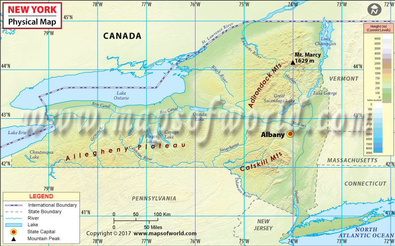
New York Physical Map
The New York Physical Map comprises an area of 54,555 square miles and it is the 27th largest state by size in the United States. Located in the northeastern US, it is the only state that borders both the Great Lakes and the Atlantic Ocean. The state borders two Great Lakes (Lake Erie and Lake Ontario), the provinces of Ontario and Quebec in Canada, and six US states.
The Great Appalachian Valley is one of the major landforms in eastern New York. In its northernmost region lies the rugged Adirondack Mountains, which run along the shores of Lake Champlain and Lake George and lie west of the Lake Champlain. The Adirondack Park – the largest state park in the US – features Mount Marcy with an elevation of 5,344 feet (1,629 meters), the highest point in New York. To the south and beyond the Mohawk Valley, the Catskill Mountains form the northeastern terminus of the Allegheny Plateau.
Mohawk Valley in Upstate New York is the region between the Catskill Mountains and the Adirondack Mountains. Hudson Highlands rise in the lower Hudson River Valley. Much of the Central New York region is dominated by watersheds of Mohawk and Hudson River. Most of the Southern New York, or the Southern Tier, rests on the Allegheny Plateau. The Niagara River, an outlet of Lake Erie, forms the mighty Niagara Falls between New York and Canada.
Finger Lakes region covers nearly 9,000 square miles of area in Western New York, which itself is a sub-region of Upstate New York. The Great Lakes lowlands and the Genesee River with its tributaries are also a part of Western New York.
