- New Mexico Counties - New Mexico County Map, Map of New Mexico Counties
- Major Cities of New Mexico - Santa Fe
- Neighbouring States - Colorado, Oklahoma, Texas, Arizona
- Regional Maps - Map of USA
- Other New Mexico Maps - New Mexico Map, Where is New Mexico, New Mexico Physical Map, New Mexico Lat Long Map, New Mexico Zip Code Map, New Mexico Area Code Map, New Mexico National Parks Map
Airports in New Mexico
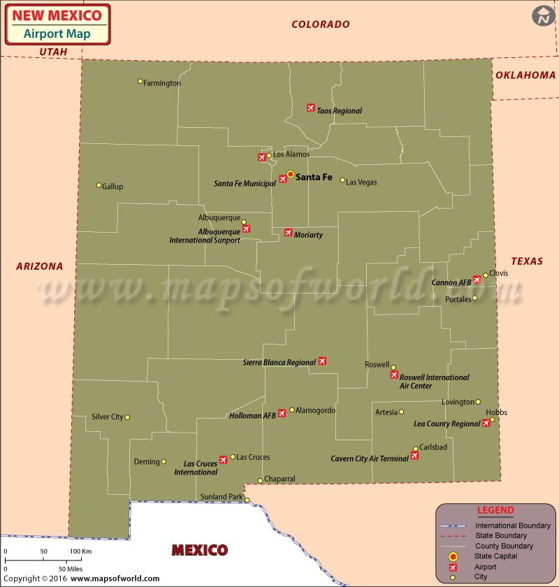
There are 62 airports in New Mexico for public use. The airports in New Mexico are well connected to international destinations and other states within the USA. The airports in New Mexico provide friendly assistance to passengers.
The international airports in New Mexico are Albuquerque International Sunport in Albuquerque, and the Roswell International Air Centre in Roswell. The Las Cruces International Airport in Las Cruces is a general aviation airport.
The important regional airports in New Mexico are the Four Corners Regional Airport in Farmington, the Los Alamos Airport in Los Alamos, the Taos Regional Airport in Taos, the Santa Fe Airport in Santa Fe, and the Cavern City Air Terminal in Carlsbad.
The Albuquerque International Sunport receives more than six million travelers every year. The amenities provided at this airport are courtesy phones for hotels, handicap assistance, eateries, lounges, ATMs, Internet kiosks, news and gift shops, retail stores, and coffee shops. In some terminals free wireless Internet access is provided.
The airlines that fly from Albuquerque Internaional Sunport are United Airlines, Northwest Airlines, Skywest Airlines, American Airlines, Mesa Airlines, Southwest Airlines, Great Lakes Airlines, Delta Airlines, and Continental Airlines.
Tickets for these airlines can be booked online. Some of the airlines provide special fares and discounts for booking their tickets online. Mapsofworld provides Allegiant Air airline flights reservations online.
The important airports in New Mexico are Farmington, Gallup, Grants, Albuquerque, Santa Fe, Ranches of Taos, Raton, Clayton, Tucumcari, Clovis, Socorro, Las Vegas, Espanola, Tucumcari, Socorro, Truth Or Consequences, Silver City, Lordsburg, Alamogordo, Artesia, Roswell, Hobbs, Las Cruces, and Colombus.
Maps of Major Airports in New Mexico
- Albuquerque International Sunport Airport Map
- Four Corners Regional Airport Map
- Las Cruces International Airport Map
- Roswell International Air Center Airport Map
- Santa Fe Municipal Airport Map
List of Airports in New Mexico |
|---|
| Airport Name | Airport Code | City | Coordinates |
|---|---|---|---|
| Albuquerque International Sunport | ABQ | Albuquerque | 35°02′21.6″N 106°36′38.8″W |
| Four Corners Regional Airport | FMN | Farmington | 36°44′28″N 108°13′48″W |
| Lea County Regional Airport | HOB | Hobbs | 32°41′15″N 103°13′01″W |
| Roswell International Air Center | ROW | Roswell | 33°18′5.6″N 104°31′50″W |
| Santa Fe Municipal Airport | SAF | Santa Fe | 35°37′02″N 106°05′22″W |
| Cavern City Air Terminal | CNM | Carlsbad | 32°20′15″N 104°15′48″W |
| Clovis Municipal Airport | CVN | Clovis | 34°25′31″N 103°04′45″W |
| Grant County Airport | SVC | Silver City | 32°38′12″N 108°09′23″W |
| Conchas Lake Seaplane Base | — | Conchas Dam | 35°23′03″N 104°12′59″W |
| Whiskey Creek Airport | — | Silver City | 32°45′43″N 108°12′30″W |
| Tatum Airport | — | Tatum | 33°15′39″N 103°16′43″W |
 Wall Maps