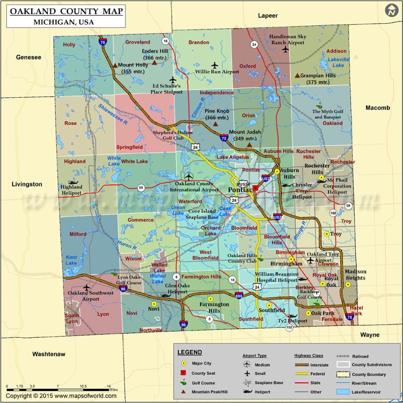
Mountain Peaks in Oakland County
| Mountain Peak/Hill | Elevation [Meter] |
|---|---|
| Bald Mountain | 331 |
| Enders Hill | 366 |
| Grampian Hills | 375 |
| Haven Hill | 342 |
| Mount Holly | 355 |
| Mount Judah | 349 |
| Pine Knob | 366 |
| Teeple Hill | 336 |
| Waterford Hill | 340 |
Airports in Oakland County
| Airport Name |
|---|
| Bendix Heliport |
| Cass Heliport |
| Cass Lake-Cove Island Seaplane Base |
| Chrysler Corp Heliport |
| Ed Schulte’s Place STOLport |
| Fuller Heliport |
| Glen Oaks Heliport |
| Guardian Industries Heliport |
| Handleman Sky Ranch Airport |
| Heliflite Heliport |
| Huron Valley Sinai Hospital Heliport |
| Independence Green Heliport |
| Kamikaze Run Heliport |
| Kamikaze Run Heliport |
| Mc Phail Corporation Heliport |
| Mc Phail Heliport |
| Mc Phail Heliport |
| Oakland County International Airport |
| Oakland Southwest Airport |
| Oakland Troy Airport |
| Olson’s Airport |
| Providence Hospital Heliport |
| Spring Lake Airport |
| Springview Municipal Airport |
| T & M Companies Heliport |
| Tv2 Heliport |
| Wagner’s Landing Heliport |
| William Beaumont Hospital Heliport |
| Zayti Field Heliport |
Cities in Oakland County
| City | Population | Latitude | Longitude |
|---|---|---|---|
| Auburn Hills city | 21412 | 42.673424 | -83.244664 |
| Berkley city | 14970 | 42.498602 | -83.185343 |
| Beverly Hills village | 10267 | 42.522042 | -83.242356 |
| Bingham Farms village | 1111 | 42.517661 | -83.278001 |
| Birmingham city | 20103 | 42.544664 | -83.216667 |
| Bloomfield Hills city | 3869 | 42.578033 | -83.245666 |
| Clawson city | 11825 | 42.536672 | -83.150415 |
| Farmington city | 10372 | 42.461382 | -83.378373 |
| Farmington Hills city | 79740 | 42.485996 | -83.377116 |
| Ferndale city | 19900 | 42.459237 | -83.131343 |
| Franklin village | 3150 | 42.518775 | -83.303035 |
| Hazel Park city | 16422 | 42.461925 | -83.097689 |
| Holly village | 6086 | 42.798744 | -83.623321 |
| Huntington Woods city | 6238 | 42.48171 | -83.168654 |
| Keego Harbor city | 2970 | 42.608663 | -83.34434 |
| Lake Angelus city | 290 | 42.692115 | -83.321457 |
| Lake Orion village | 2973 | 42.782724 | -83.245241 |
| Lathrup Village city | 4075 | 42.492109 | -83.227356 |
| Leonard village | 403 | 42.865141 | -83.142468 |
| Madison Heights city | 29694 | 42.507274 | -83.103355 |
| Milford village | 6175 | 42.587057 | -83.601219 |
| Novi city | 55224 | 42.478596 | -83.489277 |
| Oak Park city | 29319 | 42.464994 | -83.182331 |
| Orchard Lake Village city | 2375 | 42.586192 | -83.375213 |
| Ortonville village | 1442 | 42.851034 | -83.442676 |
| Oxford village | 3436 | 42.821776 | -83.256567 |
| Pleasant Ridge city | 2526 | 42.471505 | -83.144555 |
| Pontiac city | 59515 | 42.649322 | -83.287806 |
| Rochester city | 12711 | 42.686718 | -83.119675 |
| Rochester Hills city | 70995 | 42.664526 | -83.156304 |
| Royal Oak city | 57236 | 42.508395 | -83.153871 |
| South Lyon city | 11327 | 42.46129 | -83.652586 |
| Southfield city | 71739 | 42.476502 | -83.260528 |
| Sylvan Lake city | 1720 | 42.617011 | -83.333094 |
| Troy city | 80980 | 42.581734 | -83.145755 |
| Village of Clarkston city | 882 | 42.734285 | -83.420615 |
| Walled Lake city | 6999 | 42.537875 | -83.478592 |
| Wixom city | 13498 | 42.52431 | -83.534712 |
| Wolverine Lake village | 4312 | 42.555017 | -83.488254 |
 Wall Maps