US States Map > Map of Illinois > Illinois Road Map

Illinois Road Map

by Vishul Malik

Illinois Road Network The Illinois road map is an extremely useful and informative source of information about the road network in the State of Illinois. The Illinois road map provides an illustrative representation of…


Illinois Road Map

Illinois Road Network

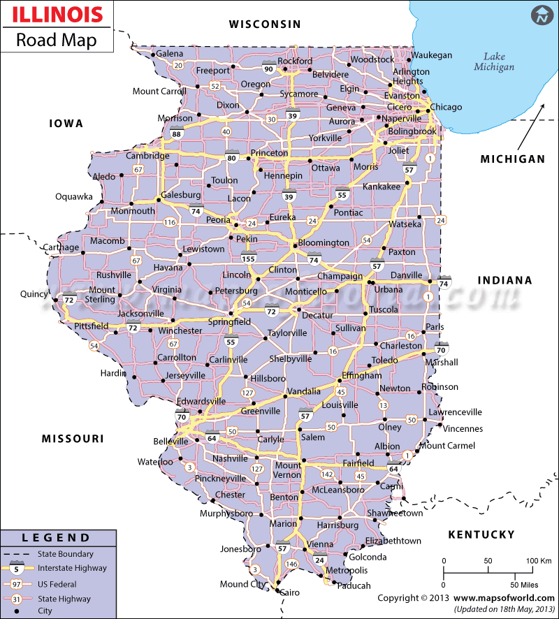
The Illinois road map is an extremely useful and informative source of information about the road network in the State of Illinois. The Illinois road map provides an illustrative representation of the national highways and prominent roads of the state.

Comprising of a number of cities and towns, Illinois is served by a well-developed network of roads. From north to south and east to west, Illinois is efficiently connected by the state highways. This road map of Illinois also serves as an Illinois highway map as it gives details about all the important highways which connect various parts of the city. This map also acts as a guide to the Illinois rail road map which follows an almost similar pattern in terms of route coverage.

According to a survey carried out in the year 2000, Illinois State possessed a total of 222,688 km of paved roadways. There are inter-state roads in Illinois that collectively offer a smooth and comfortable transportation link between different cities. For instance, south and south-west parts of Illinois are linked with Chicago by the l-57 and l-55 roadways. The east-west locations of Illinois State are connected through l-90, l-64, l-80, l-88, l-70, l-72 and l-74 roadways.

The Illinois road map is also an important tool for getting an overview of the Illinois Tollway Map as this map shows all the highways where one needs to pay toll taxes. The Illinois State Toll Highway Authority determines these taxes and regulates the smooth functioning of roads in the State of Illinois.

This comprehensive road map of the Illinois State is very useful for people who are planning to visit this city for the first time or even for people who wish to have an overview of the Illinois road network. The additional links in the page about the road maps of different US cities is also very helpful for users.

Related Maps

This website uses cookies to improve your experience. We'll assume you're ok with this, but you can opt-out if you wish. Accept Read More

Looks like your ad blocker is on.

×

We rely on ads to keep creating quality content for you to enjoy for free.

Please support our site by disabling your ad blocker.

Continue without supporting us

Choose your Ad Blocker

  • Adblock Plus
  • Adblock
  • Adguard
  • Ad Remover
  • Brave
  • Ghostery
  • uBlock Origin
  • uBlock
  • UltraBlock
  • Other
  1. In the extension bar, click the AdBlock Plus icon
  2. Click the large blue toggle for this website
  3. Click refresh
  1. In the extension bar, click the AdBlock icon
  2. Under "Pause on this site" click "Always"
  1. In the extension bar, click on the Adguard icon
  2. Click on the large green toggle for this website
  1. In the extension bar, click on the Ad Remover icon
  2. Click "Disable on This Website"
  1. In the extension bar, click on the orange lion icon
  2. Click the toggle on the top right, shifting from "Up" to "Down"
  1. In the extension bar, click on the Ghostery icon
  2. Click the "Anti-Tracking" shield so it says "Off"
  3. Click the "Ad-Blocking" stop sign so it says "Off"
  4. Refresh the page
  1. In the extension bar, click on the uBlock Origin icon
  2. Click on the big, blue power button
  3. Refresh the page
  1. In the extension bar, click on the uBlock icon
  2. Click on the big, blue power button
  3. Refresh the page
  1. In the extension bar, click on the UltraBlock icon
  2. Check the "Disable UltraBlock" checkbox
  3. Marque la casilla de verificación "Desactivar UltraBlock"
  1. Please disable your Ad Blocker

If the prompt is still appearing, please disable any tools or services you are using that block internet ads (e.g. DNS Servers).

Logo