- Colorado Counties - Colorado County Map, Map of Colorado Counties
- Major Cities of Colorado - Grand Junction, Colorado Springs, Denver, Durango, Boulder
- Neighbouring States - Wyoming, Nebraska, Kansas, Oklahoma, New Mexico, Utah
- Regional Maps - Map of USA
- Other Colorado Maps - Colorado Map, Where is Colorado, Colorado Physical Map, Colorado Lat Long Map, Colorado Zip Code Map, Colorado Area Code Map, Colorado National Parks Map
Airports in Colorado
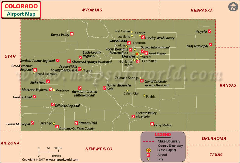
There are 79 public airports in Colorado, a state famous for its diverse topography. People flock to Colorado to see its natural beauty, and the state’s airports are well connected to serve that traffic.
Colorado’s main international airport of Colorado-Denver International Airport (DEN) is located at Denver.
The other major airports in Colorado are in Craig, Steamboat Springs, Rangeley, Ft. Collins, Greeley, Sterling, Boulder, Rifle, Grand Jct., Glenwood, Springs Leadville, Aspen, Boulder, Denver, Aurora, Akron, Sterling, Montrose, Gunnison, Salida, Colorado Springs, Limon, Pueblo, Lamar, Trinidad, Durango, Pagosa Spring, and Cortez.
Major Airports in Colorado
-
-
Aspen-Pitkin County Airport
Also known as Sardy Field, the Aspen-Pitkin County Airport is a country-owned public-use airport situated three nautical miles i.e. 6 km northwest of the central business district of Aspen, in Pitkin County, Colorado.
-
-
-
Cortez Municipal Airport
Situated three miles southwest of Cortez, in Montezuma County, Colorado, the Cordez Municipal Airport has been subsidized by the Essential Air Service program. According to the Federal Aviation Administration records, the airport possessed about 8,401 passenger boardings in the year 2008. Also, the National Plan of Integrated Airport Systems for 2011-2015 has categorized the airport as a non-primary commercial service airport.
-
-
-
Front Range Airport
This is a public airport situated on the northeastern edge of Aurora, Colorado, which is about three miles i.e. 5 km southeast of Denver International Airport. The Front Range Airport was owned by the Front Range Airport Authority until January 2014 when the airport alongwith its employees were merged with Adams County.
-
-
-
Leach Airport
As a county owned, public use airport, the Leach Airport is located in Saguache County, Colorado. The airport is situated about four nautical miles northeast of the central business district of center, Colorado, at County Road 53 & County Road C.
-
-
-
Buckley Air Force Base
This is United States Air Force base located in Aurora, Colorado and was established by the US Army in 1943. The base has been named in honor of World War 1 Army pilot First Lieutenant John Harold Buckley. As the Air Force Space Command, the Buckley Air Force Base serves more than 92,000 active duty, National Guard, Reserve and retired personnel across the Front Range community.
-
-
Stapleton International Airport
As a former airport in Colorado, Stapleton International Airport served Denver, Colorado from 1929 to 1995. It also served as a hub for Continental Airlines, People Express, the original Frontier Airlines, Trans World Airlines (TWA), Western Airlines and United Airlines. In 1995, the Stapleton Airport was replaced by Denver International Airport.
Maps of Major Airports in Colorado
- Denver International Airport Map
- Aspen Pitkin County/Sardy Field Airport Map
- Cortez Municipal Airport Map
- Front Range Airport Map
- Leach Airport Map
- Buckley Air Force Base Airport Map
- Stapleton International Airport Map
List of Airports in Colorado |
|---|
| Airport Name | Code | City | Hub | Enplanements (2015) |
|---|---|---|---|---|
| Denver International | DEN | Denver | L | 26,280,043 |
| City of Colorado Springs Municipal | COS | Colorado Springs | S | 593,246 |
| Aspen-Pitkin County/Sardy Field | ASE | Aspen | N | 233,512 |
| Grand Junction Regional | GJT | Grand Junction | N | 214,404 |
| Durango-La Plata County | DRO | Durango | N | 186,800 |
| Eagle County Regional | EGE | Eagle | N | 156,937 |
| Montrose Regional | MTJ | Montrose | N | 102,756 |
| Yampa Valley | HDN | Hayden | N | 93,896 |
| Gunnison-Crested Butte Regional | GUC | Gunnison | N | 34,412 |
| Vance Brand | LMO | Longmont | None | 5,573 |
| Cortez Municipal | CEZ | Cortez | None | 2,303 |
| Centennial | APA | Englewood | None | 250 |
| Harriet Alexander Field | ANK | Salida | None | 113 |
| Garfield County Regional | RIL | Rifle | None | 46 |
| Telluride Regional | TEX | Telluride | None | 46 |
| Rocky Mountain Metropolitan | BJC | Broomfield | None | 36 |
| Blake Field | AJZ | Delta | None | 26 |
| Front Range | FTG | Watkins | None | 25 |
| Cuchara Valley at La Veta | 07V | La Veta | None | 7 |
| Greeley-Weld County | GXY | Greeley | None | 6 |
| Stevens Field | PSO | Pagosa Springs | None | 6 |
| Holyoke | HEQ | Holyoke | None | 3 |
| Perry Stokes | TAD | Trinidad | None | 3 |
| Wray Municipal | 2V5 | Wray | None | 1 |
| Hopkins Field | AIB | Nucla | None | 1 |
| Glenwood Springs Municipal | GWS | Glenwood Springs | None | 1 |
 Wall Maps