- Arkansas Counties - Arkansas County Map, Map of Arkansas Counties
- Major Cities of Arkansas - Little Rock, Hot Springs
- Neighbouring States - Missouri, Tennessee, Mississippi, Louisiana, Texas, Oklahoma
- Regional Maps - Map of USA
- Other Arkansas Maps - Arkansas Map, Where is Arkansas, Arkansas Physical Map, Arkansas Lat Long Map, Arkansas Zip Code Map, Arkansas Area Code Map, Arkansas National Parks Map
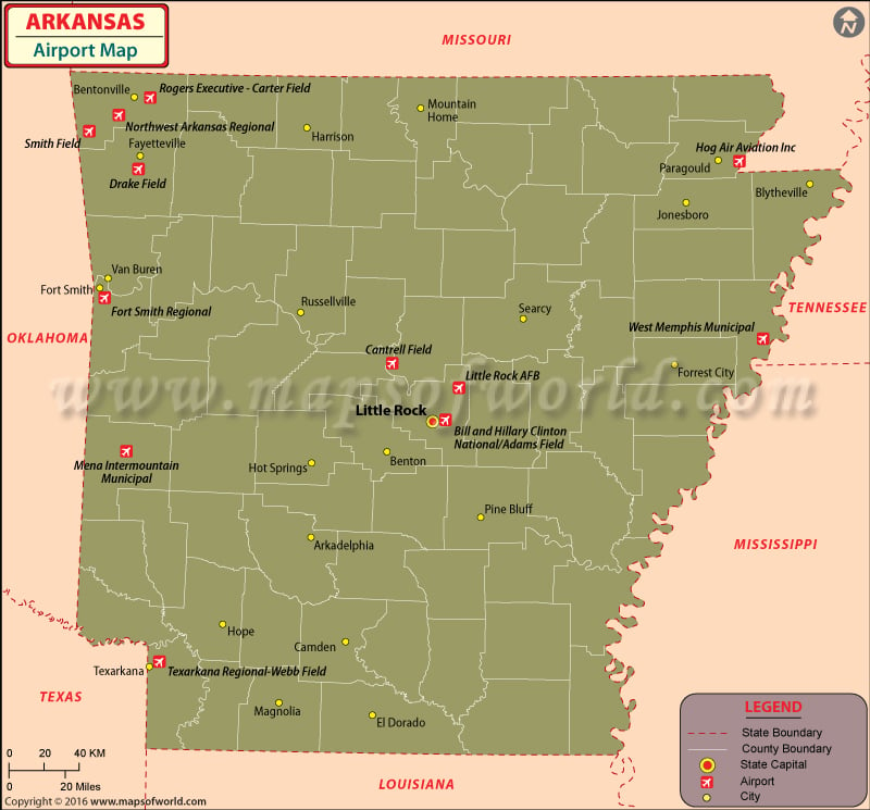
Airports in Arkansas
Arkansas is a naturally beautiful state that receives numerous visitors every year. There are many airports in Arkansas that cater to domestic travelers. Arkansas has only one international airport.
Some important airports in Arkansas are in the following cities:
|
|
Little Rock National Airport has many customer-driven projects, ensuring that the airport is kept up-to-date on technological innovations and has a high level of customer service. This national airport is connected to many cities with international airports.
In addition to catering to the general public and the military, Arkansas airports also offer hangars for private and individual fliers.
Many airlines operate at these airports of Arkansas, including The American Airlines, Delta Airlines, Continental Airlines and Northwest Airlines. These airlines offer ticketing services through their official web sites.
Major Airports in Arkansas
-
-
Fort Smith Regional Airport
As a public use joint civil-military airport, Fort Smith Regional Airport is located three nautical miles southeast of the central business district of Fort Smith, in the Sebastian County, Arkansas, United States. The airport is governed by the Fort Smith Airport Commission and has been established by the City of Fort Smith, Arkansas. Regional airline affiliates of Delta Air Lines and American Airlines are served by the Fort Smith Regional Airport.
-
Boone County Airport
Boone County Airport is a county-owned public-use airport located in Boone County, Arkansas, United States. The airport is also known as Boone County Regional Airport. It is located three nautical miles northwest of the central business district of Harrison, Arkansas and serves Branson, Missouri. The Federal Aviation Administration records reveal that the Boone County airport has had 1,903 passenger boardings in 2008.
-
-
-
Carroll County Airport
City owned and public use airport, the Carroll County Airport is located in Carroll County, Arkansas, about three nautical miles west of the central business district of Berryville, Arkansas. The airport has been categorized as a general aviation facility by the National Plan of Integrated Airport Systems for 2011-2015.
-
-
Robinson Army Airfield
As a military airfield at Camp Robinson in Pulaski County, Arkansas, the Robinson Army Airfield is located about five nautical miles northwest of the central business district of Little Rock, Arkansas. The airport serves as the home to the Arkansas National Guard.
Maps of Major Arkansas Airports
List of Airports in Arkansas |
|---|
| Airport Name | Code | City | Hub | Enplanements (2015) |
|---|---|---|---|---|
| Bill and Hillary Clinton National/Adams Field | LIT | Little Rock | S | 958,510 |
| Northwest Arkansas Regional | XNA | Bentonville | S | 629,905 |
| Fort Smith Regional | FSM | Fort Smith | N | 84,136 |
| Texarkana Regional-Webb Field | TXK | Texarkana | N | 34,881 |
| Drake Field | FYV | Fayetteville | None | 874 |
| Little Rock AFB | LRF | Jacksonville | None | 417 |
| Rogers Executive – Carter Field | ROG | Rogers | None | 56 |
| Mena Intermountain Municipal | MEZ | Mena | None | 13 |
| Hog Air Aviation Inc | 3AR9 | Paragould | None | 6 |
| West Memphis Municipal | AWM | West Memphis | None | 2 |
| Cantrell Field | CXW | Conway | None | 2 |
| Smith Field | SLG | Siloam Springs | None | 1 |
 Wall Maps