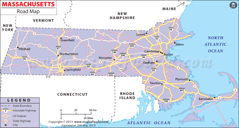
Massachusetts road map shows the detailed road network system of this northeastern US state. In addition to showing the important road networks this map also points out the major cities and locations within the state.
Massachusetts Road Route 1
The South or West Terminus of Route 1 in Massachusetts is at Rhode Island State Line (US 1) at Attleboro. The North or East Terminus of this route is at New Hampshire State Line (US 1) in Salisbury.
Massachusetts Road Route 1A
The North or East Terminus of route 1A of Massachusetts is at the New Hampshire State Line (NH 1A) in Salisbury while its South or West Terminus is at Rhode Island State Line (US 1A) in Attleboro.
Massachusetts Road Route 3
The South or West terminal of Massachusetts road route 3 is at MA 3 in Cambridge while its North or East terminal is at New Hampshire State Line (US 3) in Tyngsboro.
Massachusetts Road Route 5
The North or East Terminal of Massachusetts Road Route 5 is at Vermont State Line (US 5) in Bernardston while its South or West Terminal is at Connecticut State Line (US 5) in Longmeadow.
Massachusetts Road Route 6
The South or West terminal of Massachusetts Road Route 6 is at Rhode Island State Line (US 6) in Seekonk while its North or East terminal is at Cape Cod National Seashore in Provincetown.
Massachusetts Road Route 7
The North or East terminal of the Massachusetts Road Route 7 is at Vermont State Line (US 7) in Williamstown and its South or West terminal is at Connecticut State Line (US 7) in Sheffield.
Massachusetts Road Route 20
The South or West terminal of Massachusetts Road Route 20 is at New York State Line (US 20) in Hancock and its North or East terminal is at Kenmore Sqaure (MA 2) in Boston. The Massachusetts road map also highlights the other important national and interstate highways in the state.

 Wall Maps