In addition, MBTA runs extensive distance passenger railroad services across the Greater Boston region, which incorporate services to Providence and Worcester, Rhode Island.
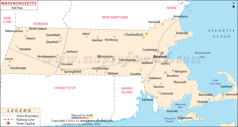
Massachusetts Rail Map :
What it shows
A Massachusetts Rail Map shows the railway network and the major stations in the state of MA.
Amtrak runs inter-city rail such as the high-speed Acela service to locations like New Haven, Providence, Washington, D.C., and New York City.
The Northeast Corridor
The Northeast Corridor is one of the few itineraries served by Amtrak and it is the most significantly traveled railroad itinerary in the nation.
The South Station of Boston is the last stop in the north with a high regularity of services.
Trains from New York arrive at Boston in approximately 3.5 hours. From Washington, it takes around twice the time. The quicker Acela trains cut down around one hour from those rides, and though they are more expensive, they usually offer a more pleasant journey.
The North Station of Boston is also served by the Downeaster, which carries passengers to Maine and New Hampshire.
Other Services
Amtrak serves Springfield with trains moving in from all the directions – north, south, east, and west. You can go there through the Northeast Regional Service of Amtrak, the Lake Shore Limited from the east and west, and the Vermonter from the north and south. With the overhaul of the Union Station in Springfield, the city will witness a rise in railroad travel in the coming years. Therefore, timetables will also vary.
Amtrak serves other Central and Western cities in Massachusetts, though the services are not so regular like Boston. The Lake Shore Limited of Amtrak serves Worcester, Pittsfield, and Framingham from the east and west.

 Wall Maps