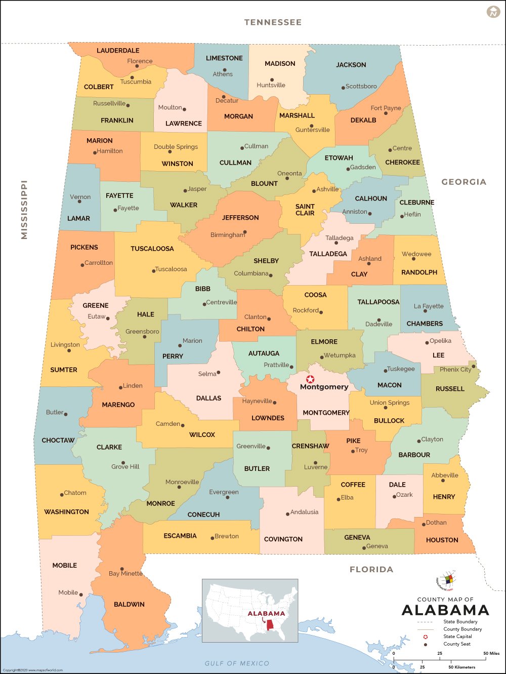
The Alabama counties map clearly defines this state’s political and administrative subdivisions in the United States of America.
Spread over a total area of 52,432 square miles, the state of Alabama is divided into 67 Counties. Each county is governed by a county seat or the administrative headquarters.
Washington is the oldest county in Alabama, which became prominent on June 4, 1800. A more recently founded county is Houston, which was formed on February 9, 1903.
Major Counties in Alabama
-
Bibb County-
The county of Bibb derived its name from Gov. William W. Bibb and was founded on February 7, 1818.
-
Chambers County-
Chambers was formed on December 18, 1832. Lafayette is the county seat of Chambers.
-
Dallas County-
Selma is the administrative headquarter of Dallas, which came into existence on February 9, 1818.
-
Elmore County-
Founded on February 15, 1866, Elmore was named after Gen. John A. Elmore.
-
Autauga-
Prattville is the county seat of Autauga. The county was founded on November 21, 1818. For more counties check: Counties in Alabama.
Maps of All Counties of Alabama
- Autauga County Map, Alabama
- Baldwin County Map, Alabama
- Barbour County Map, Alabama
- Bibb County Map, Alabama
- Blount County Map, Alabama
- Bullock County Map, Alabama
- Butler County Map, Alabama
- Calhoun County Map, Alabama
- Chambers County Map, Alabama
- Cherokee County Map, Alabama
- Chilton County Map, Alabama
- Choctaw County Map, Alabama
- Clarke County Map, Alabama
- Clay County Map, Alabama
- Cleburne County Map, Alabama
- Coffee County Map, Alabama
- Colbert County Map, Alabama
- Conecuh County Map, Alabama
- Coosa County Map, Alabama
- Covington County Map, Alabama
- Crenshaw County Map, Alabama
- Cullman County Map, Alabama
- Dale County Map, Alabama
- Dallas County Map, Alabama
- Dekalb County Map, Alabama
- Elmore County Map, Alabama
- Escambia County Map, Alabama
- Etowah County Map, Alabama
- Fayette County Map, Alabama
- Franklin County Map, Alabama
- Geneva County Map, Alabama
- Greene County Map, Alabama
- Hale County Map, Alabama
- Henry County Map, Alabama
- Houston County Map, Alabama
- Jackson County Map, Alabama
- Jefferson County Map, Alabama
- Lamar County Map, Alabama
- Lauderdale County Map, Alabama
- Lawrence County Map, Alabama
- Lee County Map, Alabama
- Limestone County Map, Alabama
- Lowndes County Map, Alabama
- Macon County Map, Alabama
- Madison County Map, Alabama
- Marengo County Map, Alabama
- Marion County Map, Alabama
- Marshall County Map, Alabama
- Mobile County Map, Alabama
- Monroe County Map, Alabama
- Montgomery County Map, Alabama
- Morgan County Map, Alabama
- Perry County Map, Alabama
- Pickens County Map, Alabama
- Pike County Map, Alabama
- Randolph County Map, Alabama
- Russell County Map, Alabama
- Shelby County Map, Alabama
- St Clair County Map, Alabama
- Sumter County Map, Alabama
- Talladega County Map, Alabama
- Tallapoosa County Map, Alabama
- Tuscaloosa County Map, Alabama
- Walker County Map, Alabama
- Washington County Map, Alabama
- Wilcox County Map, Alabama
- Winston County Map, Alabama
Related Maps
 Wall Maps